To the Editor:
In 2018, then-New Jersey Attorney General Gurbir Grewal established the Office of Public Integrity & Accountability (OPIA). At that time, Grewal said they wanted law enforcement to “root out the corruption and misconduct” that hurts faith in public institutions.
Officially, OPIA is tasked with a dual mission: To investigate violations of public trust and develop policies that would rebuild faith in both government and our criminal justice system.
The OPIA may be effective against crimes against the state, but it is a failed institution with regard to reigning in corruption of state agencies against its citizens.
It’s a well-established fact that New Jersey has riparian ownership rights of all lands that are now or were formerly flowed by tides (e.g., the ocean, bays, and tidal sections of rivers and creeks, etc.) unless that ownership has been sold by the state via a riparian grant.
In other words, if there is a former stream on your property that was filled in, then in order to obtain clear title to your property, you will need to purchase the land that was filled in from the state via a riparian grant.
Most homeowners only find out about this when they go to sell their property and a title search finds a riparian claim on the property by the state.
These homeowners then go through a lengthy process to clear the title by paying the state for the portion of the land on which there is a claim, effectively buying that land a second time.
In many cases, the claims of the state Department of Environmental Protection (DEP) are legitimate, but when you go back and look at the history of claims/grants, you will find that the DEP has been making illegitimate claims (effectively extorting money from homeowners). Let’s look at this corruption at DEP.
Prior to the 1980s, the state’s ownership was a complete fiasco. The state didn’t really have a handle on what lands it owned and didn’t do a good job of enforcing its ownership rights when lands were filled in.
To address this situation, voters passed a constitutional amendment in November 1981, requiring the state to define and assert its claims to riparian lands within one year.
At that time, the de facto standard for mapping the state’s riparian claims was for the property owner to have the tributaries on their property surveyed. Clearly, that technique would not allow the state to meet its one-year mandate for mapping claims, so the state proposed to the court that they use an aerial photography technique to identify claims, but there was opposition.
When the court reviewed this case, the court approved the photography technique, but also said that the surveying technique (which was the standard technique at that time) was entirely flawed.
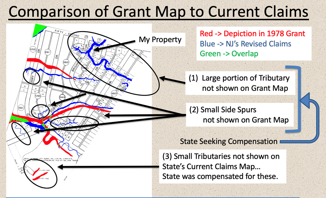
How different are the results of these two techniques? Look at the example of the Ocean City Homes development (pictured). Red depicts the survey, which was used in a 1978 riparian grant to the developer, blue depicts the aerial photography, and green depicts the overlap.
You are probably now wondering how the state handles this discrepancy. To answer that question, let’s start by putting aside the fact that the state won’t honor the words in the 1978 grant to Ocean City Homes, which clearly say that the state was assigning forever “all that tract of land now or formerly flowed by tidewaters” within the Ocean City Homes development; we all know that is a violation of public trust.
It’s straightforward for all the tributaries and side spurs not shown on the original grant map (derived from a survey), the state will make you buy a new grant.
What is more interesting is how they handle tributaries that are shown on the map, but not of the exact same location/size/shape. In that case, the state uses subjective reasoning to determine if you must buy a grant or not.
For example, does the tributary shown in red on the upper left side of the map, sort of, kind of, look like the tributary shown below it in blue? Since the blue tributary is quite a bit longer than the red rendition, the state will likely want compensation for the area beyond the perceived overlap in lengths.
If your property is comprised of a part of a blue tributary that seems to correspond to red tributary, you may think everything is good, but not so fast.
A title company will require you to pay $1,000 for a Statement of No Interest from the state, and it doesn’t end there … If you are selling your house (very likely), then you will have to escrow typically 2.5 times the value of your land encompassed by the former stream until the Statement of No Interest is issued by the state (which can take many months to years).
Of course, we all know that the state will just keep the money that they were paid for the tributaries in the bottom left of the map, which the state no longer believes even existed.
All of this is just nonsense given that the 1978 grant clearly stated that the state was assigning forever “all that tract of land now or formerly flowed by tidewaters” within the Ocean City Homes development.
It is time for Gov. Murphy to step in and end the corruption at DEP since the OPIA seems unwilling or unable to do so!


