Friday, Nov. 13:
SCHOOLS CLOSED:
Avalon Elementary
Cape May City Elementary
Margaret Mace
Ocean City
Sea Isle City
St. Ann Regional
Our Lady Star of the Sea
Wildwood schools
Wildwood Catholic High School
90-minute opening delay: Stone Harbor
A coastal flood warning remains in effect in Cape May County until 10 a.m. Saturday, November 14th. Additionally, high surf advisory is in effect until Saturday. A wind advisory is in effect through this afternoon.
There is flooding in many areas in Sea Isle City and the westside of Avalon, Stone Harbor and all of the Wildwoods are experiencing flooding.
National Guard trucks are stationed in Ocean City, Sea Isle City, Stone Harbor, North Wildwood, West Wildwood and Cape May City.
Approximately 1,200 people were without power in Cape May County of Cape May
Fare Free Transportation is operating, but not to the barrier islands. Meals on Wheels will not be delivered today to barrier island residents, but will be on Saturday. Other recipients of Meals on Wheels will receive their food today.
All senior citizens’ centers, operated by the county, are closed.
THURSDAY, NOV. 12:
COURT HOUSE – Freeholder Vice-Director Ralph E. Sheets, Jr. and Emergency Management Director Frank McCall at 6 p.m. Nov. 12, signed an Emergency Proclamation declaring a state of emergency to exist in Cape May County.
Vice-Director Sheets said, “The County has declared a state of emergency enabling authorities to take all necessary measures to protect the persons and property of the residents of Cape May County.”
Additionally, the Cape May County Emergency Management Communications Center has been activated. The Cape May County Fire Coordinator, EMS Coordinators, CBRNE Director, Cape May County Fire Chiefs Association, Cape May County Public Works Association, the Cape May County Regional Emergency Special Operations Team and the Cape May County Municipal Offices of Emergency Management are pre-positioned to respond to the potential disaster associated with the Nor’easter.
The following areas have been designated as disaster areas:
The Borough of AVALON, the City of CAPE MAY, The Borough of CAPE MAY POINT, the Township of DENNIS, the Township of LOWER, the Township of MIDDLE, the City of NORTH WILDWOOD, the City of OCEAN CITY, the City of SEA ISLE CITY, the Borough of STONE HARBOR, the Township of UPPER, the Borough of WEST CAPE MAY, the Borough of WEST WILDWOOD, the City of WILDWOOD, the Borough of WILDWOOD CREST, and the Borough of WOODBINE.
The proclamation gives the County the authority to request resources from that State of New Jersey on behalf of municipalities.
The following resources have been requested:
* Resources to assist with ATLANTIC CITY ELECTRIC COMPANY power outages that can affect all of CAPE MAY COUNTY.
* Ten HIGH WHEEL 4X4 VEHICLES have been requested for response to assist Cape May County Municipalities in Medical Emergencies.
* NEW JERSEY DEPARTMENT OF TRANSPORTATION assets will be needed to regulate traffic on SH 9, SH 47, SH 52, SH 107 & SH 147.
* The NEW JERSEY STATE POLICE TRAFFIC INCIDENT MANAGEMENT TEAM will be needed to offset potential problems in the region.
The Cape May County Office of Emergency Management is monitoring the situation and remains in constant communication with the New Jersey State Police, New Jersey Office of Emergency Management, the National Weather Service, Municipal Emergency Management Coordinators as well as other state and federal partners.
From the National Weather Service Friday morning:
.COASTAL FLOOD WARNING NOW IN EFFECT UNTIL 10 AM EST SATURDAY…
…HIGH SURF ADVISORY NOW IN EFFECT UNTIL 10 AM EST SATURDAY…
THE COASTAL FLOOD WARNING IS NOW IN EFFECT UNTIL 10:00 AM ON
SATURDAY. THE HIGH SURF ADVISORY IS NOW IN EFFECT UNTIL 10:00 AM
ON SATURDAY.
HIGH PRESSURE TO OUR NORTH AND LOW PRESSURE TO OUR SOUTH WILL
MAINTAIN A NORTHEAST TO NORTH WIND ALONG THE COASTS OF NEW JERSEY
AND DELAWARE INTO THE WEEKEND. THE FLOW WILL KEEP WATER FROM
DRAINING AWAY FROM THE COASTLINE AND TIDAL DEPARTURES WILL REMAIN
VERY HIGH. WATER WILL BE TRAPPED IN THE BACK BAYS OF NEW JERSEY AND
DELAWARE FOR AT LEAST ANOTHER FOUR OR FIVE TIDE CYCLES.
WIDESPREAD MODERATE TIDAL FLOODING IS ANTICIPATED FOR EARLY THIS
MORNING. SOME LOCATIONS IN SOUTHERN DELAWARE AND EXTREME SOUTHERN
NEW JERSEY WILL EXPERIENCE SEVERE TIDAL FLOODING. MANY ROADS WILL BE
FLOODED AND IMPASSABLE AND SOME HOMES AND BUSINESSES WILL TAKE ON
WATER. TODAY`S EARLY MORNING HIGH TIDE WILL BE THE HIGHEST OF THE
STORM.
MODERATE TIDAL FLOODING IS EXPECTED DURING THE HIGH TIDE CYCLE LATE
THIS AFTERNOON INTO THIS EVENING, AND AGAIN EARLY ON SATURDAY
MORNING. AS A RESULT, THE COASTAL FLOOD WARNING HAS BEEN EXTENDED
INTO SATURDAY.
THE HIGH SURF WILL WORSEN ANY TIDAL FLOODING AND IT WILL RESULT IN
MODERATE TO SEVERE BEACH EROSION. RAINFALL WILL ALSO ADD TO THE
TIDAL FLOODING.
WAVES OFF THE COASTS OF NEW JERSEY AND DELAWARE ARE FORECAST TO BE
IN EXCESS OF 15 FEET INTO EARLY SATURDAY. BREAKERS ALONG THE COAST
WILL APPROACH 7 OR 8 FEET AT TIMES. THE HIGH SURF ADVISORY HAS ALSO
BEEN EXTENDED INTO SATURDAY.
.WIND ADVISORY IN EFFECT UNTIL 4 PM EST THIS AFTERNOON…
THE NATIONAL WEATHER SERVICE IN MOUNT HOLLY HAS ISSUED A WIND
ADVISORY…WHICH IS IN EFFECT UNTIL 4 PM EST THIS AFTERNOON. THE
HIGH WIND WARNING HAS BEEN CANCELLED.
STRONG HIGH PRESSURE REMAINS IN PLACE OVER NORTHERN NEW ENGLAND
AS LOW PRESSURE SPINS OFF THE CAROLINA COAST. THE DIFFERENCE IN
PRESSURE BETWEEN THESE TWO SYSTEMS HAS CREATED A STRONG AND
PERSISTENT NORTHEAST FLOW ALONG THE COASTS OF NEW JERSEY AND
DELAWARE. WINDS ARE EXPECTED TO AVERAGE AROUND 20 TO 30 MPH WITH
GUSTS TO 45 MPH.
PRECAUTIONARY/PREPAREDNESS ACTIONS…
A WIND ADVISORY MEANS THAT WINDS OF 35 MPH ARE EXPECTED. WINDS
THIS STRONG CAN MAKE DRIVING DIFFICULT…ESPECIALLY FOR HIGH
PROFILE VEHICLES. USE EXTRA CAUTION.
Thursday night:
COURT HOUSE — County officials have declared a state of emergency due to the coastal storm that has resulted in flooding, and closure of highways to many barrier islands.
Firefighters from many stations have been summoned to their stations for overnight standby duty due to the storm.
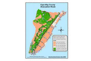
Voluntary evacuations of barrier islands were urged by county Emergency Management Director Frank McCall.
Shelters were being prepared in North Wildwood and, offshore, in Middle Township’s Davies Recreation Center in Court House.
Tides are expected to be exceptionally high, especially Friday morning, about 6:30 a.m.
Northeast winds are slowing the normal tidal movement, and back bays were flooded late in the afternoon.
Wildwood police have been answering calls of motorists driving through high water, then getting stranded and crying for help.
Wildwood police reported at 6:25 p.m. that Park Boulevard was completely under water.
EARLIER in the day:
COURT HOUSE — The Cape May County Office of Emergency Management met with local municipal emergency offices on Thursday, Nov. 12 and decided to ask barrier island residents living along the intracoastal waterway to voluntarily evacuate.
County Emergency Management Director Frank McCall told the Herald that emergency officials wanted residents to know that a high tide is expected in the early morning hours of Nov. 13.
“We wanted to give residents an opportunity to evacuate now, instead of waiting for the flooding tomorrow,” he said.
This coastal storm is expected to cause the worst flooding in years, McCall added.