Irene: New York City, Mid-Atlantic Put on High Alert
By Kristina Pydynowski, Senior Meteorologist, Accuweather
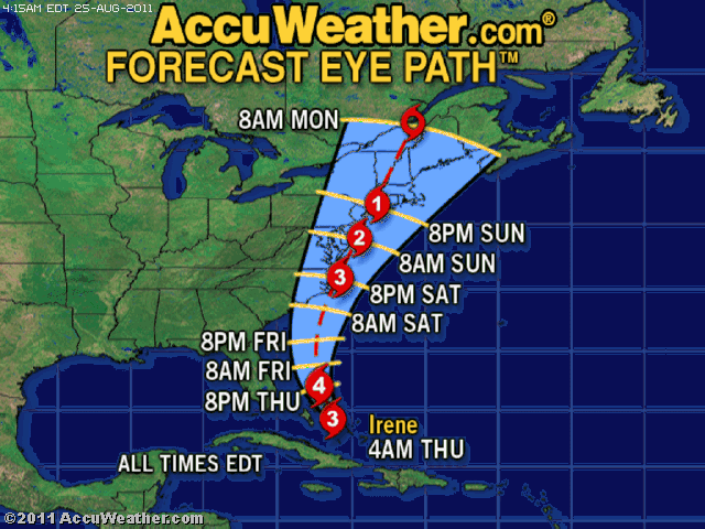
Hurricane Irene is now on a path that could take it dangerously close to, if not over, the mid-Atlantic coastline and New York City on Sunday, posing a serious danger to millions of people.
The AccuWeather.com Hurricane Center is confident that Irene will strike the Outer Banks of North Carolina Saturday evening as a strong Category 3 or Category 4 hurricane.
Beyond that point, latest indications put Irene on a path extremely close to or over the mid-Atlantic coast and New York City before plowing into western New England.
Irene is expected to track near the mouth of the Chesapeake Bay and Delmarva coast Saturday night, then could pass within 30 miles of New York City Sunday evening as a weakening Category 2 hurricane.
Such a path would lead to severe impacts that could prompt officials to force evacuations. All residents and visitors in the path of Irene should heed these orders if issued and prepare homes and businesses for Irene’s onslaught in the meantime.
On its current forecast path, Irene would spread destructive hurricane-force winds (gusts between 80 to 100 mph) across the Delmarva coast, eastern New Jersey, New York City, western Long Island and southwestern New England.
A track directly over Atlantic City, N.J., and New York City would bring these intense winds westward to Philadelphia.
The strongest and most sustained hurricane-force winds will be measured in the immediate vicinity of Irene’s center.
Widespread tree damage, major power outages and structural damage to buildings and homes would ensue. Glass windows could shatter along the sides of New York City skyscrapers.
Damaging tropical storm-force winds (winds between 40 and 70 mph) will extend 150 miles westward and nearly 250 miles eastward from Irene’s center.
These winds will likely Richmond, Va., Baltimore, Md., Philadelphia, Pa., Albany, N.Y., and nearly all of New England, threatening to cause significant tree damage and power outages.
The winds will have no trouble downing trees where recent flooding and record rainfall has saturated the ground, such as in Philadelphia and New York City.
Irene will also cause extremely rough surf to pound the entire mid-Atlantic and New England coastline with severe beach erosion and significant coastal flooding an almost certain guarantee.
A flooding storm surge will further inundate the coastline.
Yachts and boats docked along the mid-Atlantic and New England coasts should be moved to higher ground if possible.
The worst case scenario in terms of flooding storm surge for New York City and the mid-Atlantic coast would be Irene tracking directly overhead or slightly to the west.
Places along and west of the center will be subject to Irene’s heaviest rain.
The current path of Irene puts places from eastern North Carolina to eastern Pennsylvania, eastern New York and western New England at risk to receive 4 to 8 inches of rainfall with locally higher totals.
That rain alone will trigger widespread flooding issues, but AccuWeather.com is extremely concerned for serious flood problems where recent heavy rain has already saturated the ground.
The drainage systems in Philadelphia and New York City are sure to get overwhelmed.
“Since a small jog to the west or east would lead to a huge difference in impacts, [AccuWeather.com meteorologists] suggest monitoring this situation closely,” cautioned AccuWeather.com Hurricane and Tropical Weather Expert Meteorologist Dan Kottlowski to all residents and visitors in the mid-Atlantic and New England.
It is not totally out of the question that Irene tracks farther eastward than currently forecast. Such a track would shift the zone of flooding rain farther eastward and cause eastern New England to endure the brunt of Irene’s destructive winds and coastal flooding.
Bulletin
Hurricane Irene advisory number 21
NWS National Hurricane Center Miami,Fla.
11 a.m.EDT Thur. Aug. 25, 2011
Dangerous Hurricane Irene turns north-northwestward…Core
approaching Abaco Island…
Location…25.9n 76.8w
About 75 mi. NNE of Nassau
About 645 mi.. S of Cape Hatteras, North Carolina
Maximum sustained winds…115 mph.
Present movement…NNW at 13 mph.
Minimum central pressure…951 or…28.08 inches
Warnings will likely be required for portions of the watch area
Later today, the hurricane watch will also likely need to be
extended northward along the Mid-Atlantic coast later today.
Interests elsewhere in the Mid-Atlantic states and New England
should monitor the progress of Irene.
A tropical storm watch has been issued from north of Edisto Beach
South Carolina to Surf City, North Carolina.
A turn toward the north-northwest is expected today, followed by a turn toward the
north by early Friday. On the forecast track, the core of the
hurricane will continue to move over the northwestern Bahamas
today and pass well offshore of the east coast of central and
North Florida tonight and early Friday.
Irene is a Category Three hurricane. Some strengthening is expected today and
tonight.
Irene is a large tropical cyclone. Hurricane force winds extend
outward up to 70 miles from the center and tropical-
storm-force winds extend outward up to 255 miles.
Storm surge…In areas of onshore winds near the center of Irene…
An extremely dangerous storm surge will raise water levels by as
much as 7 to 11 feet above normal tide levels over the Bahamas.
Near the coast, the surge will be accompanied by large and
dangerous waves.
Rainfall…Irene is expected to produce rainfall accumulations of 6
to 12 inches over the Bahamas during the next 36 hours. Rains will
be diminishing across the Turks and Caicos islands with additional
rainfall amounts of 1 to 3 inches possible bringing the maximum
storm total to 6 to 12 inches.
Surf…Swells generated by Irene will begin affecting portions of
the coast of the southeastern U.S. today. These swells are
expected to cause life-threatening surf and rip current conditions.
From the National Weather Service-Mount Holly-Hurricane Discussion:
The Saturday and Sunday forecast has been adjusted based on the
new 11 a.m. track forecast from the National Hurricane Center. The track is now bringing
the storm right up the Delaware and New Jersey coasts. This will bring hurricane
force winds to all marine areas and to much of eastern Delaware and New Jersey.
The wind gusts were capped at 92 knots for now.
The main focus for this period continues to be the track and
impacts of Hurricane Irene. We want to stress that it is important
to not focus on the exact forecast track of the storm, especially
for the longer range, since errors are up to 200 miles /the storm
Is not a single point/.
We expect impacts from this hurricane generally occurring Saturday night
through about midday Sunday. The exact track of the hurricane as
It moves by our region will determine the overall impacts, however
there remains a rather elevated potential for serious impacts on
our area from this hurricane. Everyone should be preparing for
this large storm as now is the time. Have a plan in place.