COURT HOUSE – National Weather Service (NWS) has upgraded the tropical storm watch to a tropical storm warning for our area.
A tropical storm warning means sustained winds of 34 to 63 knots or 39 to 73 mph are expected due to a tropical storm within 36 hours.
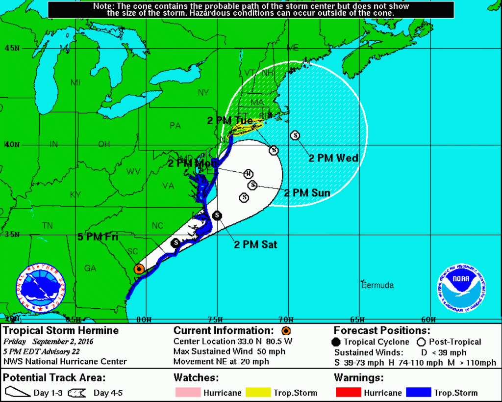
According to NWS’ latest briefing as of 5 p.m. Sept. 2, “Tropical Storm Warning issued for the New Jersey coastal counties (Monmouth to Cape May to Salem), all of Delaware and for all of our coastal waters including all of Delaware Bay … There remains quite a bit of uncertainty with the track east of our coasts Sunday through Monday, as the storm should slow and meander some which will prolong the coastal and marine impacts.”
Likely hazards, according to NWS:
Coastal Flooding/Beach Erosion: High Confidence. Areas of minor flooding beginning with the Saturday evening high tide, then minor to moderate flooding Sunday morning and evening. Widespread moderate flooding Monday morning, with areas of major flooding especially from Atlantic City south to coastal Delaware. Coastal flooding may continue into Tuesday. Given multiple rounds of tidal flooding, water in the back bays will have a hard time draining between tidal cycles which should lead to prolonged and significant flooding in these locations. Additionally, there could be tidal flooding into the upper portions of Delaware Bay and the tidal Delaware River, including Philadelphia. The combination of higher than normal tides and heavy rain will cause flooding of streets and low lying places in the coastal areas this weekend. Be careful where you park your car. Significant beach erosion expected due to large wave action and this prolonged event.
Strong Wind: Moderate confidence. Tropical storm force winds, sustained wind of 39 mph or greater, with higher gusts for at least the coastal counties (areas under the warning). Strongest winds should occur Saturday night into Monday. A further west track would bring stronger winds more inland, however the winds are expected to decrease quite a bit further inland.
Heavy Rain: Moderate Confidence. A sharp western cutoff of the heavy rain is expected, and this will be dependent on the exact track. Areas with the highest risk for heavy rain are Delmarva and eastern New Jersey. The heaviest rain should occur Sunday into Monday. The primary flooding hazard will be street and flash flooding. The recent dry weather will lessen but not eliminate the risk of river and stream flooding.
Rip Current Risk: High Confidence. Moderate to high risk through at least Labor Day, and may continue Tuesday. Beach goers should only enter the water if lifeguards are present, and as conditions worsen are urged to stay out of the water. High and dangerous surf is expected.
View the latest briefing here.
NWS will release their next briefing at 9 a.m. Sept. 3.
According to local meteorologist Dan Skeldon, “Coastal residents should brace for a long duration battering of wind, tidal flooding, and beach erosion.”
The City of North Wildwood in a Sept. 2 release advised residents and visitors alike of the potential for minor flooding Sept. 3 and moderate coastal flooding Sept. 4 as a result of Hermine.
“With the potential for high winds, residents and visitors are reminded to secure all properties and belongings including lawn chairs, umbrellas and trashcans,” North Wildwood stated in the release. “Also forecasted is the potential for 4-6 inches of rain, which due to slow runoff, may cause extended and localized flooding in areas that do not normally experience tidal flooding. Residents and visitors are advised to never drive down a flooded roadway.”
Middle Township Police Department released a statement from Mayor Michael Clark Sept. 2 advising residents to expect increased tidal flooding in areas that are regularly affected.
“Have a plan to move vehicles to higher ground and secure items that may be blown away by storm surges or wind gusts,” stated Clark in the release.
Lower Township Police Department advised residents Sept. 2 to sign up for Nixle alerts to receive notifications regarding Hermine. Residents may sign up by texting LTPD to 888777, or by visiting, https://local.nixle.com/signup/widget/m/1188/.
Atlantic City Electric (ACE) in a Sept. 1 release warned residents of possible power outages as a result of forecasted strong winds and heavy rain.
“ACE customers can prepare for the storm by being ready for any outages,” according to the release. “ACE asks customers to have an emergency kit, including a flashlight, battery-powered radio, extra batteries, non-perishable food, bottled water, manual can opener, cash, any essential medications and a list of important phone numbers. All items can be placed into a large cooler which can be used at home and is easy to grab if a person has to leave home quickly.
“Customers are also encouraged to identify a safe alternate location in case of an extended outage; tune to local news broadcasts for the latest weather and emergency information and follow the advice of local emergency management officials.”
ACE customers are asked to report any outages and to stay away from any downed wires. To report outages and/or downed wires, call 1-800-833-7476, or visit atlanticcityelectric.com or use the company’s mobile app.
South Jersey Gas in a Sept. 2 release offered tips to prepare for Hermine before, during and after the storm. View those tips here.
Resources are also available on Cape May County’s Emergency Management website, http://www.capemaycountyemergency.net/, including an emergency preparedness guide, evacuation route map, etc.
Be sure to continue to monitor NWS’ latest forecasts for updated information at http://www.weather.gov/phi/.