In December the Army Corps of Engineers released a new draft plan for protecting the back bay areas of New Jersey from the ravages of storms and sea level rise, a plan that updates one released in 2021. It arrives with some significant changes to the earlier document.
The most significant change is cost, with the updated plan estimated at $8 billion compared to the $16 billion price tag on the 2021 version.
The new plan also says that at least 1,436 residential and commercial structures in the back bay areas of Cape May County should be elevated, and that at least 63 structures such as hospitals and police and fire stations need to be flood-proofed. The numbers do not include Ocean City, which the plan puts in a separate region and for which figures were not immediately available.
The plan says the state and local share of the $8 billion cost would be $3 billion. It sets the year 2041 for completion of construction.
What happened to reduce the cost of the new plan compared to 2021’s was that costly structural elements of the original plan were removed. These called for inlet floodgates that would prevent surging water from getting into the back bays, barriers that would close off inlets at the threat of major storms. It also called for floodwalls, levees and seawalls, all hard structures that are expensive and controversial.
The 400-page draft report states that the “structural plans in the 2021 report were determined to be inactionable and not implementable.” Removing the structural components caused the estimated price to decline, but it also placed greater reliance on plans for elevating buildings, flood-proofing critical facilities and heavier use of nature-based solutions to build up marshes and wetlands so they better absorb storm surges.
The structural recommendations have not been totally abandoned, but they have been put aside. The report states that “the evaluation of these structural plans is contingent on the availability of funding.”
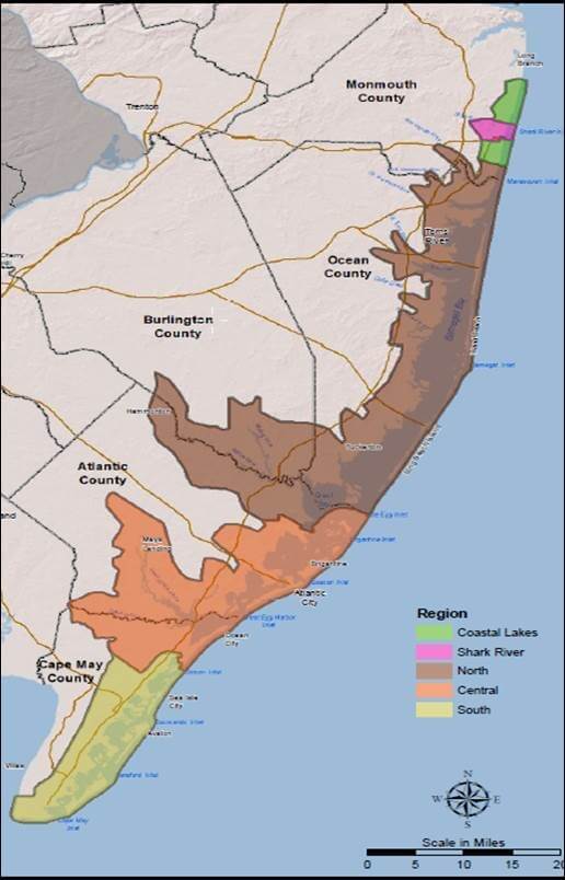
The study area is huge, and Cape May County does not cleanly sit in any one of the sections designated within it. The new draft, entitled the New Jersey Back Bays Coastal Storm Risk Management Study, encompasses an area of 950 square miles, 3,400 miles of shoreline, parts of five counties, and 89 municipalities.
The study area is broken into five regions, of which the most southern takes in Cape May County and 15 of its 16 municipalities. The northern cutoff point for the southern region is Corson Inlet, meaning Ocean City is not included in that region. The five regions were defined by hydrology, not governmental boundary lines.
For the southern region, 1,436 structures, both residential and commercial, are designated as in need of elevation. The southern region also has 63 structures that are considered critical facilities that would require flood-proofing because they do not lend themselves to being elevated. These include hospital, police, fire and ambulance facilities, among others.
In summary, nearly a quarter of the structures designated as in need of elevation in the entire study area lie within the boundaries of Cape May County – minus Ocean City, which would add significantly to the number.
A look at the county structures as they appear in the report gives another view of the size of the task. Cape May County has 57,923 structures that were considered in the report. Many areas along the Delaware Bay side of the county are not designated as being within the study area, keeping that figure lower than it might otherwise have been.
What stands out as a problem for the entire study area is the plethora of municipal jurisdictions. The report says the “study area lacks a comprehensive, multijurisdictional, multiagency effort that can integrate coastal storm risk management efforts.”
The cost of what is called the Tentatively Selected Plan is high even with the elimination of the original structural components, but the number that really gives pause is the expected contribution from the non-federal sponsor, that being the state and local share. That number in the updated and downsized plan is $3 billion.
The report, when it discusses nonstructural solutions, includes relocation: “Nonstructural [Coastal Storm Risk Management] measures include acquisition and relocation, building retrofits, flood warning and evacuation planning, and programmatic considerations, such as land use and floodplain management and zoning.”
The Army Corps and the state Department of Environmental Protection will host a virtual public meeting on Jan. 22 from 6 to 7 p.m. to provide additional information on the draft report and study. The public is invited to comment on the report by Feb. 18.
Information on participation in the virtual meeting and on how to offer comment on the report can be found at https://bit.ly/40qPPsD.
Contact the reporter, Vince Conti, at vconti@cmcherald.com.


