TRENTON — New Jersey has been named a Bicycle Friendly State (BFS) by the League of American Bicyclists. The Garden State was awarded a bronze medal for ranking eighth friendliest state in the union, likely in part to the many bicycling opportunities in Cape May County.
The BFS program recognizes states that actively support bicycling. The rankings are based on a 95-item questionnaire that evaluates a state’s commitment to bicycling and covers six key areas: legislation, policies and programs, infrastructure, education and encouragement, evaluation and planning, and enforcement.
“We are delighted to report that states, and statewide bicycle advocates, are using this program to target legislative changes, adopt new policies and even start new advocacy groups in order to improve conditions for cyclists,” said Andy Clarke, League President.
State officials are happy with the recognition.
“NJDOT has made great strides to improve the conditions on our roadways for bicyclists as well as pedestrians,” Transportation Secretary Jim Simpson said. “The Department continues to invest in intersection and roadway improvements statewide that are designed to keep our pedestrians and bicyclists safe.”
Locally, there are many biking opportunities in Cape May County, with numerous bike trails and bike lanes in municipalities throughout the county.
Some local bike paths include:
• Belleplain State Forest about 40 miles of trails off Route 550
• Cold Spring trail about three miles running from Sandman Boulevard Sally Marshall Crossing
• Middle Township trail about a mile running from Goshen Road near Church Street to Court House-Dennisville Road near the 4-H grounds
• Wildwood Crest trail running from East Cresse Avenue to East Rambler Road;
• Woodbine Railroad Trail about three miles running adjacent to Lincoln Park.
Biking is also allowed at certain times on different boardwalks and promenades in the area and on most roadways at all times. County bicyclists, however, should keep in mind that bike traffic is restricted by regulations on the Garden State Parkway and Route 52.
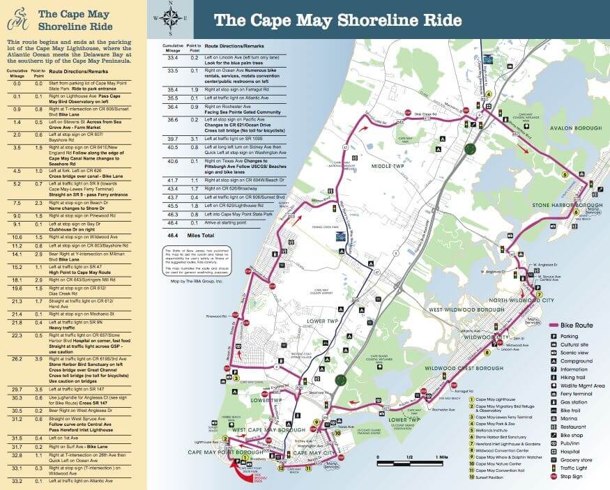
In addition, NJDOT in September 2008 issued a bike tour route map that makes a loop of the central and southern parts of the county.
The Cape May Shoreline Ride begins and ends at the Cape May Lighthouse where the Atlantic Ocean meets the Delaware Bay. The 46-mile route encompasses the best of the bayside and seaside sights of the county from the Cape May National Wildlife Refuge, the beaches of Stone Harbor and the Wildwoods as well as the Victorian architecture of Cape May.
NJDOT publishes 13 other bike maps for tours across New Jersey including the 238-mile High Point to Cape May Bike Route that travels the state from top to bottom.
When the Shoreline Ride map was released, then Gov. Jon Corzine said the “bicycle guides will provide new sightseeing opportunities at diverse agricultural, architectural, historic and natural locations…The guides will promote New Jersey’s strong ecotourism and tourism markets and encourage residents to improve air quality, congestion and quality of life by riding bicycles.”
Cape May Shoreline Ride – Click here for a pdf copy of NJDOT’s Cape May Shoreline Ride bike tour of the county. –Click Here


