UPDATE (June 13, 4:00 p.m.)
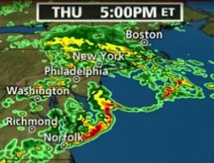
A system of potentially severe weather continues to march eastward, expected to arrive in Cape May County in the early evening of June 13. A variety of factors – including holdover effects from morning storms – may serve to moderate the effects of these storm conditions.
Morning storms were accompanied by reports of downed trees and some utility lines in the local area. A sink hole emerged in the vicinity of Exit 58 on the Garden State Parkway, resulting in closure of northbound lanes and rerouted traffic.
The Cape May County Park and Zoo closed due to down trees and damaged power lines. Zoo Personnel enacted their severe weather protocol early this morning which included locking down and taking animals off exhibit. No animals were injured during the weather event.
While there is hope for less severe conditions with the approaching weather system, preparation and caution is advised.
EARLIER REPORT –
Cape May County is under a severe thunderstorm watch until 11 a.m., with a threat of severe weather continuing into the evening of Thursday, June 13
The National Weather Service reports a line of thunderstorms is headed toward Cape May County. The conditions associated with this storm line include heavy rains and high winds, with gusts up to 60 mph.
This weather system is followed by another, potentially more forceful, line of thunderstorms which is expected to arrive by late afternoon or early evening.
For information about storm-related preparations, see this article: www.capemaycountyherald.com/article/storm/92781-during+and+after+thunderstorm


