SILVER SPRINGS, MD – An “above normal” Atlantic hurricane season is being predicted by the National Oceanic & Atmospheric Administration (NOAA) and residents are urged to plan now and prepare “early on” whether they live on the coast or inland.
“We can’t predict now how many storms will hit land,” said Neil Jacobs, Ph.D., acting NOAA administrator, during a press conference May 21. “But we encourage everyone to pay attention to the hurricane center’s warnings, especially this year with COVID-19 impacting all of our safety. Take precautions into planning now, whether you live on the coast, but also if you live inland because we’ve seen the damage by flooding and strong winds. Now is the time to prepare.”
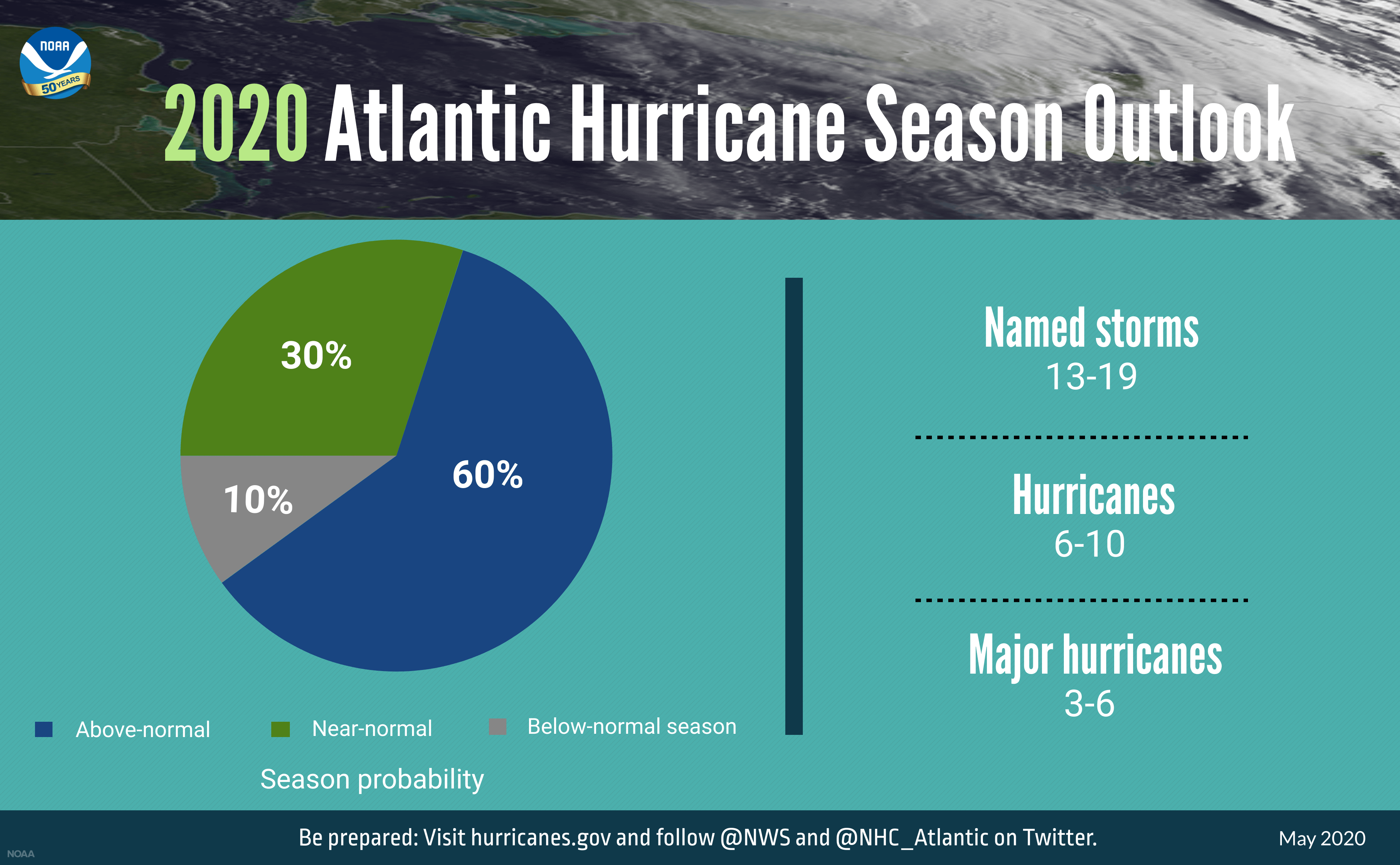
NOAA’s Climate Prediction Center is forecasting a likely range of 13-19 named storms (winds of 39 miles per hour (mph), of which 6-10 could become hurricanes (winds of 74 mph or higher), including 3-6 major hurricanes (category 3, 4, or 5, with winds of 111 mph). NOAA provides these ranges with a 70% probability or confidence level, according to Jacobs. An average hurricane season produces 12 named storms, of which 6 become hurricanes, including 3 major hurricanes.
The outlook predicts a 60% chance of an above-normal season, a 30% chance of near-normal season and only a 10% chance of a below-normal season, Jacobs said.
The Atlantic hurricane season runs from June 1 – Nov. 30.
According to Gerry Bell, Ph.D., lead hurricane season forecaster with NOAA’s Climate Prediction Center, the above-normal activity continues to be related to what he called the “high activity era since 1995.”
“The combination of several climate factors is driving the strong likelihood for above-normal activity in the Atlantic this year,” Bell said. “Warmer-than-average sea surface temperatures in the tropical Atlantic Ocean and Caribbean Sea, coupled with reduced vertical wind shear, weaker tropical Atlantic trade winds, and an enhanced west African monsoon all increase the likelihood for an above-normal Atlantic hurricane season.”
He said the Caribbean Sea is one-degree Fahrenheit warmer than average and the Gulf of Mexico is also warmer than average now, but did not indicate how much warmer.
In addition, El Nino Southern Oscillation (ENSO) conditions are expected to either remain neutral or to trend toward La Nina, meaning there will not be an El Nino present to suppress hurricane activity. (El Nino refers to the warming of sea temperatures while La Nina refers to the cooling. ENSO conditions refer to the variations in sea surface temperatures, rainfall, air pressure and atmospheric circulation.)
As storms show signs of developing, NOAA hurricane hunter aircract will be prepared to collect data for forecasters and computer models, according to Wilbur Ross, U.S. Secretary of Commerce.
“NOAA also is launching new upgrades to products and tools that will further improve critical services during the hurricane season,” he said.
NOAA will upgrade the hurricane-specific Hurricane Weather Research and Forecast system (HWRF) and the Hurricanes in a Multi-Scale Ocean Coupled Non-hydrostatic model (HMON) this summer. HWRF will incorporate new data from satellites and radar from NOAA’s coastal Doppler data network to help produce better forecasts of hurricane track and intensity during the critical watch and warning timeframes.
HMON will undergo enhancements to include higher resolution, improved physics and coupling with ocean models, he added.
As the hurricane season gets underway, NOAA will begin feeding data from the COSMIC-2 satellites into weather models to help track hurricane intensity and boost forecast accuracy, the weather officials said. COSMIC-2 satellites provide data about air temperature, pressure and humidty in the tropical regions of the Earth, where the hurricane and tropical systems form.
Also during the 2020 hurricane season, NOAA and the U.S. Navy will deploy a fleet of autonomous diving hurricane gliders to observe conditions in the tropical Atlantic Ocean and Caribbean Sea in areas where hurricanes have historically traveled and intensified.
As with every hurricane season, officials also stressed the need to be prepared.
“Social distancing and other Centers for Disease and Prevention Control guidance to keep you safe from COVID-19 may impact the disaster preparedness plan you had in place, including what is in your go-kit, evacuation routes, shelters and more,” said Carlos Castillo, acting deputy administrator for resilience at FEMA.
“With tornado season at its peak, hurricane season around the corner, and flooding, earthquakes and wildfires a risk year-round, it is time to revise and adjust your emergency plan now,” he stressed. “Natural disasters won’t wait, so I encourage you to keep COVID-19 in mind when revising or making your plan for you and your loved ones, and don’t forget your pets.
“An easy way to start is to download the FEMA app today,” he added (https://www.fema.gov/mobile-app).
The Climate Prediction Center will update the 2020 Atlantic seasonal outlook in August, prior to the historical peak of the season, which is August, September and October.
To contact Karen Knight, email kknight@cmcherald.com.


