STATE COLLEGE, PA. — AccuWeather.com on Friday, Jan. 30, reports the storm that could bring a major snowfall to parts of the East next week is part of the major weather change going on across the country. AccuWeather.com Expert Meteorologist Joe Bastardi says the pattern across the eastern part of the country will yield several major snowstorms that could bring snowfall for the year above normal in many areas, including the major cities along the I-95 corridor.
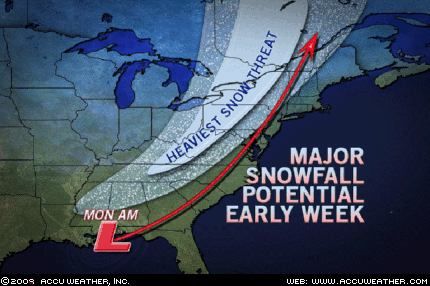
The storm coming Monday, Feb. 2 and Tuesday, Feb. 3 will track from the Gulf of Mexico to a position near Baltimore by Tuesday morning.
The storm will take shape on Sunday, spreading rain over Louisiana and neighboring states. The storm will then race through the South on Monday (Groundhog Day) to reach the Northeast by Tuesday.
The exact track of the storm will draw the line between which areas of the East receive substantial snow or heavy rain. It will also determine how many places in the Southeast will be threatened by severe weather.
A track along or just west of the Appalachian Mountains would result in disruptive snow from the Ohio Valley to the eastern Great Lakes. Soaking rain would spread over the rest of the Eastern Seaboard with potentially damaging thunderstorms from the eastern Carolinas to Florida.
A plethora of moisture being drawn into the storm could produce one to two inches of rain. Flooding could ensue, especially in the Northeast where the frozen ground will not be able to soak up the rain water.
A deep snowpack over New England and the mid-Atlantic’s interior will further heighten the potential for flooding. If the snow fails to absorb all of the rain, the combination of rain and melting snow could severely swell streams and rivers.
Substantial snow, not flooding, would threaten the Northeast’s interior if the storm tracks along the Interstate 95 corridor. Snow would blanket the major Interstate 95 cities with an offshore storm track.
The farther east the storm travels, the fewer areas in the Southeast will be threatened by damaging thunderstorms. Florida, however, will likely not escape being a target.
Where the heavy snow eventually falls, travel and daily routines will be greatly impacted. The snow could leave 6 to 12 inches with totals up to 2 feet not out of the question.
As the storm pushes through the South and cold air plunges towards the Gulf Coast, accumulating snow may even hinder travel as far south as northern parts of Mississippi, Alabama and Georgia on Monday.
The storm will intensify over the Northeast or eastern Great Lakes on Tuesday, potentially leading to dangerous blizzard conditions to the west of its center. Severe blowing and drifting snow with extremely poor visibility will make travel nearly impossible.
Regardless of the storm’s track, harsh cold and blustery winds will grip the entire eastern third of the nation in its wake Tuesday into Wednesday. AccuWeather.com RealFeel® temperatures will be significantly colder than actual thermometer readings.