A county-commissioned report on soon-to-be-proposed state regulations concerning climate change and coastal zone flooding protection found that they would have serious and far-reaching negative consequences for both island and mainland communities in Cape May County.
The report, by the Lomax Consulting Group, an environmental consulting firm, is in response to 1,057 pages of regulations that the state Department of Environmental Protection is expected to publish in the New Jersey Register Aug. 5.
The regulations stem from Gov. Phil Murphy’s Executive Order 100, issued in 2020 and instructing the DEP to incorporate predicted future impacts of climate change into the state’s land resource protection rules.
At the heart of the state’s proposed regulations is their reliance on a controversial 2019 study that projected a sea-level rise of 5 feet by the year 2100. Based on that projection, the DEP would create a new inundation risk zone that puts 43% of the county land mass, mainland and shore, in that zone, with some island communities better than 80% in the zone and one community, West Wildwood, 98% within it.

Development within that zone would be subject to stricter standards than the rest of town. The definition for inundation used by the DEP is an area of permanent standing water all day or twice a day with tides.
The Lomax report says, “The barrier island municipalities will be the most significantly impacted by the IRZ [inundation risk zone] in terms of percentage of total inundated land area, whereas the mainland municipalities will have significantly larger impacted acreage by the IRZ for which larger scale development will be impacted.”

The report also states that the new state regulations could have a major impact on proposed new housing stock on the mainland, which has potential policy implications for the development of needed affordable housing.
The new regulations, if they are ultimately adopted by the state, also would have substantial impact when it comes to flood insurance. The Lomax report shows that for Cape May County as a whole, the regulations’ addition of land to the FEMA-mapped floodplain, with all the rules that would then apply, would amount to a 16% expansion of the area. In Cape May City and West Cape May, the increase would be more than 40%.
Presentations Set
The proposed state regulations are Phase II of the DEP’s Resilient Environments and Landscapes regulations (REAL). Phase I of REAL dealt with inland flood protection rules in July 2023. Phase II is the extension of that effort to the state’s coastal zones.
Peter Lomax of the Lomax Consulting Group is making the rounds of municipal governing body meetings, presenting his company’s analysis. He appeared before the Lower Township Council on Monday, July 15, and the Stone Harbor Council the next day. Both Cape May City and Middle Township have announced similar presentations in August.
The Lomax report is in the form of a memorandum of 11 pages, followed by exhibits, graphics and appendices that summarize the new regulations’ impact on several aspects of existing regulations under the administrative code for Coastal Zone Management, Freshwater Wetlands Protection Act, Flood Hazard Area Control Act, Stormwater Management, and the new area of Inundation Risk Zone Required Analysis.
The report deals with a complex regulatory environment while attempting to make the content accessible to municipal officials and county residents who might find it difficult to wade through the regulations document itself.
The DEP has offered its own interpretation of the regulations. On May 10, DEP Commissioner Shawn LaTourette held a media briefing about them, and in a 10-day period from May 20 to 29, the agency held a series of four webinars on various aspects of the regulations.
Projection Defended
The agency’s use of a projected 5-foot sea-level rise comes from a 2019 Rutgers Science and Technical Advisory Panel report that predicted a 17% chance of a 5.1-foot rise in sea level by the end of the century under moderate emissions activity.
In the DEP webinar presentations, the agency defended that sea level rise projection, calling it the best science available.
The Lomax report notes that the DEP “selected the more conservative prediction designating a 5-foot sea level rise and establishing the year 2100 as the planning horizon for REAL rule proposed regulations.”
The implication of this set of decisions by the agency is the addition of 5 feet to coastal zone elevation requirements for new construction, redevelopment and major renovations, and the requirement to plan now for a projected outcome that has a 76-year horizon.
The proposed new inundation risk zone would work in tandem with the new Flood Risk Notification Law, enacted in July of 2023. That law requires that owners of real estate for sale or rent within the zone disclose the potential risks to buyers and tenants. That law went into effect in March of this year.
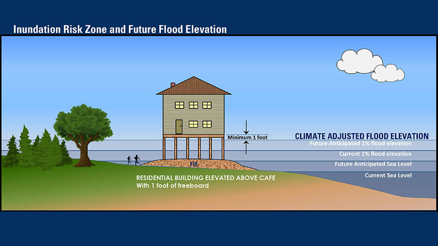
In addition to the inundation risk zone, the regulations establish Climate Adjusted Flood Elevation (CAFE) requirements that would go into effect now for potential inundation heights by 2100. In tidal areas, the standard would be 5 feet above the level set by FEMA for a 100-year storm.
During the DEP webinars, the public was told that the new regulations would add only 1.5% more land to the FEMA-mapped floodplain; that calculation was for land statewide. But the Lomax report notes that for Cape May County, an additional 16%, not 1.5%, of the land would join that category. The report says the 1.5% statement by the DEP does not reflect the “substantial impairment of lands in Cape May County.”
Study Challenged
Opposition to the proposed regulations is growing as challenges to the science on which it is based grow.
The predictions of sea level rise are based largely on a combination of predictions of melt water from glaciers and ice sheets and thermal expansion of seawater as it warms. NASA satellites routinely measure the weight of glaciers and ice sheets.
Results show that they are shrinking. But the predictions of the 2019 Rutgers study have since been countered by other studies that came up with significantly lower projections of sea level rise.
The National Oceanic and Atmospheric Administration published a sea level rise report in 2022 concluding that “about 2 feet of sea level rise along the U.S. coastline is increasingly likely between 2020 and 2100.”
The NOAA report states that sea level rise could exceed that 2-foot level and acknowledges that sea-level rise will vary regionally along the coast due to land height — New Jersey’s coastal area is very slowly sinking, studies have found, while at the same time sea levels are projected to rise.
The presentations by Lomax in Stone Harbor and Lower Township state that the science of sea-level rise has progressed since 2019. Yet when the DEP’s Vince Mazzi was asked during a May webinar whether the selection of 5 feet as the addition to flood elevation was still in line with scientific projections, his reply was that there is a greater worry at DEP that 5 feet is not enough rather than that it is too much.
The DEP essentially argues that the best science, which is what it is directed to rely on by Murphy’s 2020 executive order, has not changed.
Pushing for Change
And the agency is not alone in its insistence that the significant changes to coastal zone regulations contained in REAL are necessary.
In April, 31 environmental groups wrote to Murphy pushing for the REAL regulations to be published and saying there is an “ever-decreasing window for these rules to be proposed and adopted during your tenure.”
The announcement that FEMA Region 2 is currently updating its flood insurance rate maps for communities in coastal New Jersey has not slowed the New Jersey rulemaking process. The DEP schedule apparently does not await the completion of FEMA’s work.
In the area of coastal climate protection regulations, the REAL regulations interact with the state Planning Commission on matters of development. They offer more support for wind farm development, an important topic in Cape May County, by facilitating the process of getting transmission cables established ashore.
The regulations also rely on the 2020 New Jersey Scientific Report on Climate Change projections of increased annual precipitation and its effect on stormwater management practices.
LaTourette said in his May press conference that the extended planning horizon, the reliance on the 2019 sea level rise predictions, the expansion of inundation risk zones and the broader intrusion of the state rules into local development all are necessary for adaption to what he termed the unavoidable impacts of climate change.
County Resolution
The county has countered the DEP assertions with a draft resolution that it hopes each of the 16 municipalities will pass. Cape May City passed the resolution on July 16.
The resolution calls for an “incremental and targeted approach” to the adoption of REAL regulations. It points out, among many observations, that the “rules as currently written do not consider the economic impact these new standards may have on the ratables, real estate values, development and redevelopment statewide, but especially in Cape May County.”
The county resolution questions the science used by the DEP, raises concerns with the extended planning horizon and states the county’s belief that a “more gradual and balanced approach is necessary to target incremental adjustments over time in order to mitigate the potential negative impacts that these radically changing rules will have on the coastal towns of New Jersey.”
The county argument that the REAL regulations do not take into account the economic impact of the regulations that flow from it is identical to the opposition the county spearheaded to the Orsted offshore wind project. The economic impact and strategies to ameliorate it must be part of the analysis of drastic changes in rules, the county says.
If the regulations are published on Aug. 5, as expected, there will be a required 90-day public comment period along with at least three virtual public meetings. Dates for the hearings will not be firm until the regulations are published. The state has one year from the date of publication to adopt them.
Contact the reporter, Vince Conti, at vconti@cmcherald.com.