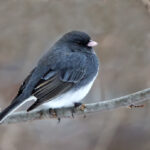
Cape May County’s location halfway along the Atlantic Flyway, a coastal migration route for migratory birds, means we see more bird variety on the Cape than nearly anywhere in the world. Our wetlands, swamps, creeks, and forests set a gorgeous backdrop for bird-watching and quiet nature walks. But far more than birds call these places home. It’s never a bad idea to bring a book, find a bench along a trail, and see what shows up. Bring bug spray, shoes that can get wet – and most importantly, eyes open for beauty and a heart to appreciate it.
Woodcock Trail – Cape May Court House
1.2 mile loop – Street parking – Trailhead at 16 Woodcock Rd.

Woodcock Trail is a 1.2-mile loop hidden behind a residential neighborhood, on a piece of land protected by the US Fish and Wildlife Service. Variety is the name of the game here; you’ll first trek through a sandy half-mile “tunnel” of dense evergreens that gives shade even on a hot summer walk. The canopy of trees eventually gives way to a small meadow that sits at the forest’s edge. A short spur takes hikers to the edge of a salt marsh, where thousands of dragonflies spawn in the summer. You’ll see – and hear – a large variety of birds in this section of the Cape May National Wildlife Refuge. The federally protected Refuge, of which Woodcock Trail is a part, allows this coastal slice of land to sit undivided by development and the ecosystem fragmentation that comes with it. This is a truly wild hike that’s worth coming to several times – you’re bound to see something new each visit. In the spring you might see the Mourning Cloak butterfly, with somber red wings outlined in bright yellow. The Southern gray Tree Frogs that live here are camouflaged well, but follow their mating calls and you might spot one on tree bark or in a nearby spit of water. These frogs sing together in chorus at night.

Many of the trees in these woods are conifers, so a winter trek here is still chipper and green. Don’t touch the skunk cabbage if you see it – the leaves emit a horrific odor. That’s a gross, incredible defense mechanism. Expect to find eastern bluebirds, Tufted Titmouse, and other native birds here in the winter, too. The trailhead’s location means that, even in peak season, it isn’t crowded. So you – yes you – check it out!
Lizard Tail Swamp – Cape May Court House
3-mile loop – Free parking lot at Trailhead, 460 Court House / South Dennis Rd

The enchanting Lizard Tail Swamp trails are home to what the Nature Conservancy, which protects the property with help from state and federal funds, calls “globally rare” lowland swamps. These are coastal freshwater marshes under 100 meters in elevation. The ground here is almost always moist and soggy, but not because of standing water like most of the county’s wetlands but because of rainwater and river runoff that penetrates deep into the ground. You’ll see lots of fungi as a result, poking out of trees, logs, and the mossy earth.

The first part of the 3-mile trail takes you right through the lowland swamp, home to some of the biggest trees we’ve seen in Cape May County: swamp cottonwood trees. They are herculean – their bark is thick and scaley, like the sagging scales of an aging dragon. The second half of the trail, well-maintained and easy to follow, brought us into the trail system’s second major biome, a more common coastal forest. We passed by several clean benches on our way and were happy to see corridors of green evergreens over sandy trails.
There’s a part of the walk that cuts right through major thicket patches. The trails were wide enough on our early spring visit that we didn’t worry about getting snagged, but it might be an issue if you come here later in the summer.
You’ll find the Lizard’s Tail plant in the swamp if you come here then. These titular plants are native to America’s eastern coast and curl at their ends like the tip of a curious lizard’s tail. This trail is teeming with life – frogs and amphibians of all types, migratory and local birds, wild blueberries and strawberries – so it’s worth coming multiple times to glimpse something new and beautiful. Just don’t forget the bug spray.
Cape May Point State Park
2 miles+ of trail loops – Free parking lot – can’t miss it
Cape May Point State Park – you know it, we know it, this is a must-visit spot in Cape May County with a trail network that is more robust than appears on first sight. The 0.5-mile red, 1.2 mile yellow, and 1.5 mile blue trails offer different glimpses at critical dune habitats, maritime forests, freshwater wetlands, and other habitats that give shelter to local and migratory creatures. If you start on the blue trail from the parking lot, pay attention when the dune section of the walk begins. Take a left when you see a pond (usually filled with swans) on your right and dunes straight ahead – take a left here to connect to the nearby South Cape May Meadows trail system.


The state park is always battling invasive species that threaten the ecological diversity for which it is known; you might see sectioned-off areas where invasive species like privet, clematis, and porcelain berry are being removed before they can do further damage.
No matter where you go on these trails, the park has the most “views per mile” of any location on this list. It’s fun to think of the trail network like a maze; just go down any spur that catches your eye and you’ll end up somewhere worthwhile without getting lost. Several spots along the path provide views of the wetlands via docks that extend onto the water. In Do the Shore’s professional opinion, the highlight is a narrow sandy section near the end of the yellow trail clamped by water and tall grasses on each side.
Garret Family Preserve – Cape Island
2+ miles of loops – Free parking lot at 801 Wilson St on Cape Island

An old cargo train, nearly overtaken by greenery, sets the stage at the Garret Family Preserve: this is a place retaken by nature, all the prettier for it.
The entrance to the preserve is off the beaten path behind several single-family properties. Because of this, I have found that the trails are lightly trafficked even in the summertime. The parking lot, installed when the land was rededicated by the Garrett family in 2015, is small but frequently has open spots.
The main attraction is the two-mile “railroad” loop that, for much of its distance, parallels an old freight line. Part of this perimeter trail is complemented by vine-covered wooden arches.

The south end of the loop has a small branch-off with a bird-viewing lean-to and a step-off to the right that reveals a massive stretch of wetlands. The splendor of this specific view can’t be overstated; there are few places in Cape May that have such a naked, quiet view of protected wetlands.
The preserve is frequently home to songbirds like the Perched Tree Swallow, Yellow-rumped Warbler, and the Eastern Meadowlark, as well as larger birds like Ospreys and Great Egrets. The entire preserve is covered in plants that weave into the local ecological cycles and systems of Cape May; the Nature Conservancy was sure not to introduce non-native species to the property. In the summertime, visitors can expect to see fields of pink milkweed, purple New England aster, and tall yellow goldenrods.
All of the plant life here is part of a truly local ecosystem- like it would be if man had not developed the island. There is something great to see here at any time of the year. The vibes are good even during Cape May’s dreariest months.
The Preserve has amenities and landmarks unique to this Nature Conservancy location: a shaded pavilion nestled in a flowered corner, a bird blind that gives the widest view of the wetlands that I can think of, a “braille trail”, a massive butterfly sculpture, maintained bee hives, and easels set up for artists to paint.
But don’t be fooled by the above-average human-made accommodations: Lillian Armstrong with the NJ Audubon stressed to me that this is a “critical piece of habitat” that, after being redeveloped into something resembling its natural state, welcomes birds as they rest on their journey south along the Atlantic Flyway.
Like the Cape May Point State Park trails, the length of the main walking loop is deceptive. The outer loop on the forest edge is two miles long, but many smaller loops with unexpected delights are found throughout. An inner loop takes you through a lot of the highlights. We love the “green tunnels” (our words) of sandy paths that are pinched between varied greenery.
Corson’s Inlet State Park
Drive to the end of Jake’s Landing Road in Woodbine – Free parking year-round
Cape May County’s third state park is one of its most vulnerable – Corson’s Inlet State Park is one of the only stretches of undeveloped shoreline land on the state’s coast and is home to vulnerable species like Piping Plovers, whose population has been threatened for decades by habitat loss. Located at the southern end of Ocean City, this is a great place to sunbathe and to sit and truly hear silence- a rare commodity on Jersey beaches. Three short trails have great views of the ocean and the undisturbed coastal forests found here, but they only last about a mile and aren’t all connected.
Still- this is a great place to visit and embrace the art of chilling out. A boat ramp, with access for boats of all kinds, is open year-round, 24 hours a day. Beach access is restricted here during nesting season for plovers – be a dear and mind the signs. This critical ecosystem is one of the last of its kind. Before the words “Jersey Shore” left someone’s mouth for the first time, the entire coast of New Jersey was populated by dune ecosystems and oceanside forests. Corson’s Inlet is one of the only places like it in the state.
South Cape May Meadows
1-mile loop with spurs – connection to Cape May Point State Park
Free parking year-round at 692 Sunset Blvd, Cape May

You’ve probably heard the story – South Cape May was a town built on the southern tip of the island until 1936, when nature decided “Yeah, that’s enough” and sunk the whole thing into the ocean. Today, the wetlands near the old town have been transformed into a 200-acre nature preserve with a loop that offers panoramic views of the surrounding marsh.

The preserve, owned by the Nature Conservancy, is full of native fauna and undisturbed marshland that attracts hundreds of species of birds. A massive floating bird blind on the east side of the trail is a great place to camp out for a bit to see who shows up. A nearby viewing platform with binoculars overlooks a water canal, the levels of which can be controlled by a dam structure that doubles as a footbridge. During Hurricane Sandy, the water level was lowered because the folks at the Nature Conservancy knew they were in for a huge tidal surge. In the spring, the Nature Conservancy says that they lower the water level to create mudflats that allow sandpipers to feed below the mud.

So to say that this property is “all natural” betrays the hard work it took to achieve the harmony that exists there today. Invasive Phragmites, the common reeds you’ll see everywhere on the American East Coast, choked out local plants integral to local food chains. It took intense years of controversial burning, spraying, and cut-down initiatives to control the Phragmites that once plagued the property. Just because an area was left alone for many years does not mean it is “natural” – nearby development brought invasive species and pollution, and sea level rise further complicates things. But for now, the South Cape May Meadows is one of the best places to see what Cape Island would look like if humans never made it their home. It just takes a lot of intentional effort to keep it that way.
Belleplain State Forest – Woodbine
8+ miles of trails, swimming, camping
1 Henkinsifkin Road, Woodbine – Check their Facebook for events and group hikes

Thank the Great Depression for this one – Belleplain State Forest was established in 1928 by the Civilian Conservation Corps, a government program spearheaded by FDR that provided millions of young men (sorry, ladies) with work in a time of economic and social despair. Many of Belleplain’s amenities, its trails, dams, roads, and even Lake Nummy itself, were whipped together by scrappy young 20th-century men through this program.
Lake Nummy is an enchanting 26-acre lake. It was once a highly profitable cranberry bog, but was turned into a day-use lake by the Civilian Conservation Corps. Those young men dug the bog into the much deeper Lake Nummy. A trail runs parallel to the lake through a plush corridor of trees. There’s a 7-mile trail, the East Creek Trail, for those with a bit more stamina. There are lots of driving trails, too, for the insect-averse.

The Lake Nummy Day Use Area, at the end of the North Trails in Belleplain State Forest, is sprawling. There are dozens of picnic tables, canoes for rent, and a sandy beach area great for a picnic.
The trail was well-marked and easy to follow. Many educational plaques stood along the way, still readable despite their age. Educational signs make us feel well-read and bookish, if just for a second.
We saw southern red oak trees, pitch pines, and American holly trees whose bright green leaves glittered in the mid-afternoon’s dull winter sunlight.

The state forest is a favorite of Lillian Armstrong, who works with the NJ Audubon. She told us “You go from a barren forest in the winter to the whole emergence of the foliage in spring. It’s suddenly filled with birds – and as soon as things quite down bird-wise, the mountain laurel blooms. A bike ride or walk anywhere there is an absolute must.”
The amenities on offer at Belleplain put it a step above any hiking spot we’ve been to in the county. Check out the park’s 169 camp, 14 lean-tos, yurts, or small shelters. NJ residents can rent a spot for as little as $20 a day, and if you want a small cabin, that’s only $45 a night. That sure beats market rate.
Jake’s Landing
Drive to the end of Jake’s Landing Road in Woodbine – free parking year-round

Jake’s Landing is one of the only places on the Cape where you can drive out onto the wetlands. The scene is dramatic; you drive through a mile-long stretch of forest and suddenly the trees give way to panoramic wetlands and “ghost forests” on the horizon, killed by saltwater intrusion as the sea level rises.
LeeAnn Haaf, PhD and an Estuary Science Assistant who studies the marshes out here, told me that the “landing” at the end of the road was used for shipbuilding in the 18th century.

We’ll share what she told us:
“Salt marshes can be difficult to gain access to, so that makes Jakes Landing a good place to visit. There’s plenty of unique fauna there, especially birds. You can hear or see birds that specialize in the salt marsh system (like Clapper Rails). What’s unique about Jakes Landing is that it likely has a history of much more freshwater discharge (both somewhat recently as well as a 500+ years ago), such that its wet forested fringes were Atlantic white cedar swamps (which have no salt tolerance). As sea levels have risen, and humans have altered the landscape, salty water has been creeping upslope and the marshes have expanded inland. This is a natural process, but the white cedars that grew there more recently succumbed to the salty water rather quickly, leaving dozens of acres of standing dead trees– a ghost forest. There’s only a few other places in NJ you can see this (like in the Mullica River), but Jakes Landing is the only place in NJ along the Delaware Bay with it so obvious.”

Look behind you as you drive out onto the wetlands and you’ll see the ghost forests right away. Despite the spooky name, this is a great place to bring your hatchback for a picnic. I like to fly my kite here and see what birds show up. When we visited last, a lady in her bright red Mustang set up shop right by the water, book in hand, and looked like she was living life to the fullest. So if you wanna see the wetlands, this is one of the best places to do it.