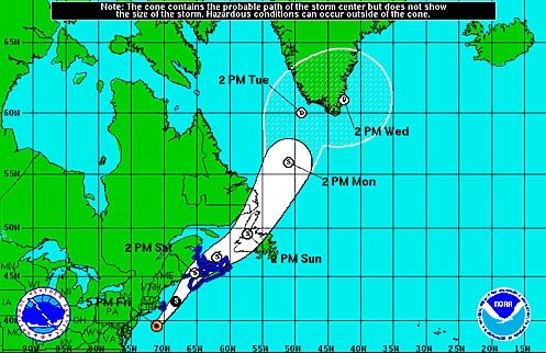
COURT HOUSE – At 5:00 p.m. Friday, July 4, Tropical Storm Arthur was located about 170 miles south-southwest of Massachusetts, according to the National Hurricane Center. Motion was northeast at 26 mph. Max sustained winds were 80 mph. The latest track from the National Hurricane Center (NHC) says the center of Arthur will pass southeast of New England tonight and be near or over western Nova Scotia early on Saturday over the Gulf of St. Lawrence Saturday night.
“So far the biggest danger from this storm will be the major rip current threat that will be posted through Sunday, July 6. The forecast for Saturday and Sunday is sunny and hot and the concern is that beach goers will want to go in the water unaware of the danger,” said Cape May County OEM Director, Martin Pagliughi in a release. Beach Patrols have all been notified of this threat, Pagliughi added.
Additional weakening of Arthur is forecast during the next 48 hours and Arthur is expected to become a post-tropical cyclone by Saturday morning.
Arthur passed well off the New Jersey and Delaware coasts today. Generally rain-free conditions are expected this evening just in time for any fireworks displays.
However, rip currents will be a major threat throughout the July 4th holiday weekend, even though after today, the rest of the holiday weekend looks quite nice.
Be sure to check www.weather.gov/phi for the latest information.
Wildwood Crest – Several of Donald Trump’s Cabinet picks have created quite a bit of controversy over the last few weeks. But surprisingly, his pick to become the next director of the FBI hasn’t experienced as much…


