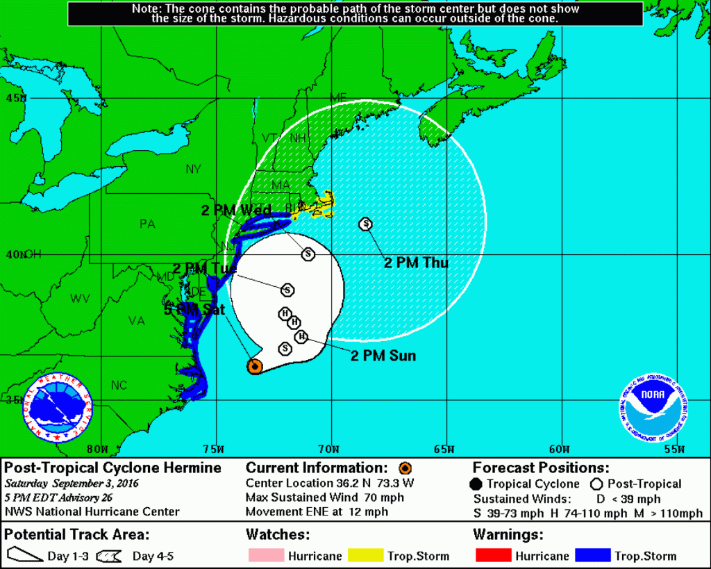
COURT HOUSE – Cape May County remains under a tropical storm warning, according to National Weather Service (NWS).
A tropical storm warning means sustained winds of 34 to 63 knots or 39 to 73 mph are expected due to a tropical storm within 36 hours.
According to NWS’ latest briefing as of 5 p.m. Sept. 3, there are no significant updates from their previous briefing released at 10 a.m. Sept. 3 which stated, “Tropical Storm Warning continues for the New Jersey coastal counties (Monmouth to Cape May to Salem), all of Delaware and for all of our coastal waters including all of Delaware Bay … There still remains some uncertainty with the track of Hermine Sunday through Monday, as the storm is expected to slow and meander which will, in turn, prolong the coastal and marine impacts.”
Likely hazards, according to NWS:
Coastal Flooding/Beach Erosion: High Confidence. Areas of minor flooding beginning with this evening’s high tide, then minor to moderate flooding Sunday morning. Widespread moderate to major flooding is now expected with the Sunday evening high tide and the Monday morning high tide, especially from Atlantic City south to coastal Delaware, when the storm is expected to make its closest approach to the area. Coastal flooding may continue into Tuesday. Given multiple rounds of tidal flooding, water in the back bays will have a hard time draining between tidal cycles, which should lead to prolonged and significant flooding in these locations. Near record flooding is forecast for Cape May. Additionally, there could be tidal flooding into the upper portions of Delaware Bay and the tidal Delaware River, including Philadelphia. The combination of higher than normal tides and heavy rain will cause flooding of streets and low lying places in the coastal areas this weekend. Be careful where you park your car. Access roads into and out of the barrier islands are likely to be cut off. Significant beach erosion is also expected due to the large wave action over the course of several days.
Strong Wind: Moderate confidence. Tropical storm force winds, sustained wind of 39 mph or greater, with higher gusts for at least the coastal counties (areas under the warning). Strongest winds should occur Sunday into Monday.
Heavy Rain: Moderate Confidence. A sharp western cutoff of the heavy rain is expected, and this will be dependent on the exact track. Areas with the highest risk for heavy rain are Delmarva and eastern New Jersey. The heaviest rain is expected to occur Sunday into Monday, with 1 to 3 inches or more near the Delaware and southern New Jersey coast. The primary hazard will be street and poor drainage area flooding. The recent dry weather will lessen, but not eliminate, the risk of river and stream flooding.
Rip Current Risk: High Confidence. Moderate to high risk through at least Labor Day, and may continue through Tuesday. Beach goers should only enter the water if lifeguards are present, and as conditions worsen are urged to stay out of the water. High and dangerous surf is expected.
View the latest briefing here.
NWS will release their next briefing by 9 a.m. Sept. 4.
Be sure to check the Herald’s Facebook page, https://www.facebook.com/heraldnewspapers/, and Twitter page, https://twitter.com/HeraldNews, for the most updated information.
Additional resources are available on Cape May County’s Emergency Management website, http://www.capemaycountyemergency.net/, including an emergency preparedness guide, evacuation route map, etc. Access NWS’ Tropical Storm and Hurricane Preparedness Information here.
Be sure to continue to monitor NWS’ latest forecasts for updated information at http://www.weather.gov/phi/.
Wildwood – So Liberals here on spout off, here's a REAL question for you.
Do you think it's appropriate for BLM to call for "Burning down the city" and "Black Vigilantes" because…


