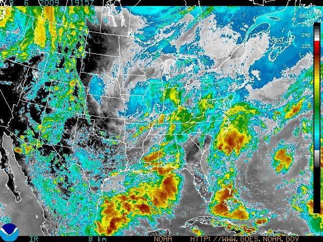
STATE COLLEGE, Pa- Weak low pressure gathering over warm waters off the Carolinas will have the potential to instigate disruptive weather along a stretch of the Eastern Seaboard during the first part of the week.
The low will deepen somewhat as it tracks slowly northward along the North Carolina Outer Banks to the Virginia Capes through Tuesday. It should shift away from the coast midweek.
One aspect of this coastal low will be its potential to drop heavy or even excessive rain near the immediate coast between Cape Hatteras and Delaware Bay. Brisk easterly winds north of the low will aim rough surf towards beaches as far north as New Jersey . Tides will be elevated a little compared to normal.
Drenching rain overspreading the Carolina coastline will likely keep many beachgoers indoors on Labor Day. It cannot be ruled out that the storm delivering the rain takes on some tropical characteristics.
Gusty winds will also blow onto the beaches, mainly to the north and east of the developing storm’s center.
The winds will keep the danger of rip currents high and the surf rough from Long Island to North Carolina into Labor Day. The rip current threat will be elevated at other Southeast beaches.
AccuWeather.com meteorologists, including Joe Bastardi, are closely monitoring this storm for the possibility that it develops tropically. The storm could take on tropical characteristics by spending enough time over the warm waters off the Southeast coast.
The departure of the rain from most Carolina beaches will coincide with the end of the Labor Day holiday weekend. On Tuesday, the rain will wet places from south of New York City to Cape Hatteras.
Atlantic Tropical Weather Outlook
——————————————————————————–
000
ABNT20 KNHC 061745
TWOAT
TROPICAL WEATHER OUTLOOK
NWS TPC/NATIONAL HURRICANE CENTER MIAMI FL
200 PM EDT SUN SEP 6 2009
FOR THE NORTH ATLANTIC…CARIBBEAN SEA AND THE GULF OF MEXICO…
A BROAD AREA OF LOW PRESSURE LOCATED JUST OFFSHORE OF THE COAST OF
SOUTH CAROLINA IS PRODUCING DISORGANIZED SHOWERS AND THUNDERSTORMS.
UPPER-LEVEL WINDS ARE NOT CONDUCIVE FOR TROPICAL CYCLONE FORMATION
AS THIS SYSTEM MOVES SLOWLY NORTH-NORTHEASTWARD. THERE IS A LOW
CHANCE…LESS THAN 30 PERCENT…OF THIS SYSTEM BECOMING A TROPICAL
CYCLONE DURING THE NEXT 48 HOURS.
AN AREA OF DISTURBED WEATHER NEAR THE COAST OF AFRICA…ABOUT 400
MILES EAST-SOUTHEAST OF THE CAPE VERDE ISLANDS…IS ASSOCIATED WITH
A STRONG TROPICAL WAVE. CONDITIONS APPEAR FAVORABLE FOR SLOW
DEVELOPMENT OF THIS SYSTEM AS IT MOVES WESTWARD OR
WEST-NORTHWESTWARD NEAR 15 MPH OVER THE NEXT COUPLE OF DAYS. THERE
IS A MEDIUM CHANCE…30 TO 50 PERCENT…OF THIS SYSTEM
BECOMING A TROPICAL CYCLONE DURING THE NEXT 48 HOURS.
ELSEWHERE…TROPICAL CYCLONE FORMATION IS NOT EXPECTED DURING THE
NEXT 48 HOURS.
Cape May – Governor Murphy says he doesn't know anything about the drones and doesn't know what they are doing but he does know that they are not dangerous. Does anyone feel better now?


