By Gina Cherundolo, AccuWeather.com Staff Writer
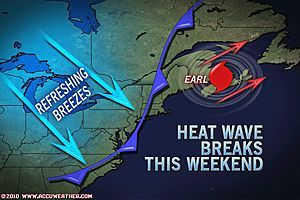
The latest heat wave across the Midwest and Northeast is reaching its peak and will break this weekend as Hurricane Earl completes a run up the Atlantic Seaboard.
In the process, southwest winds on the back side of the high will continue to bring higher humidity into the region Wednesday as temperatures climb well into the 90s.
Wednesday marks the first day of September, and AccuWeather.com Expert Senior Meteorologist Dan Kottlowski reminds people that a hot day in September is not the same as a hot day in June.
“Everything else being equal, a 90-degree day on Sept. 1 will not feel as bad as one on June 1,” he said. “The sun is lower in the sky, and the rays will be more spread out than in June when the sun is higher.”
A mass of cool air is approaching the East, but Hurricane Earl churning in the Atlantic will keep the front at bay until the weekend.
Friday will be a transition day in terms of temperature. The coastal areas will already have temperatures trimmed by Hurricane Earl, while Great Lakes and Ohio Valley areas will feel the first effects of the cold front pushing eastward.
This will create a “squeeze play” for a narrow portion of the Northeast, which will still have hot, humid conditions on Friday. This area includes the Carolinas, portions of the mid-Atlantic and New England, and Nova Scotia and New Brunswick.
Once Earl makes its way northward toward Nova Scotia and Newfoundland, the much cooler, less humid air will spread throughout the mid-Atlantic, Northeast and Midwest, dropping high temperatures as much as 20 degrees.
Wildwood – So Liberals here on spout off, here's a REAL question for you.
Do you think it's appropriate for BLM to call for "Burning down the city" and "Black Vigilantes" because…


