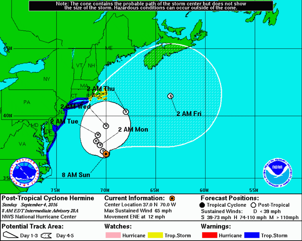
COURT HOUSE – Cape May County remains under a tropical storm warning, according to National Weather Service (NWS).
A tropical storm warning means sustained winds of 34 to 63 knots or 39 to 73 mph are expected due to a tropical storm within 36 hours.
According to NWS’ latest briefing as of 9 a.m. Sept. 4, “Observed tidal departures range from +1.0 to +2.0 feet this morning, and continue to slowly increase with the persistent onshore flow. Given a slightly more eastward track, expected forecasted maximum tide heights have been reduced slightly, and it now appears that the Monday morning high tide may be the worst. Moderate flooding is expected with tonight’s high tide, and moderate to major flooding is likely with the Monday morning high tide. Likewise, the axis of heavy rain is now expected to remain well off the coast closer to the center of the storm, and so estimates of the heaviest rainfall have been reduced.”
Likely hazards, according to NWS:
Coastal Flooding/Beach Erosion: Significant Impact. Generally minor flooding is expected with this morning’s high tide. Widespread moderate flooding is now expected with this evening’s high tide. For the Monday morning high tide, especially from Atlantic City south to coastal Delaware, moderate to major flooding is expected. Coastal flooding may continue into Tuesday. Given multiple rounds of tidal flooding, water in the back bays will have a hard time draining between tidal cycles, which should lead to prolonged and significant flooding in these locations. Additionally, there could still be tidal flooding into the upper portions of Delaware Bay and the tidal Delaware River, including Philadelphia. The combination of higher than normal tides and heavy rain will cause flooding of streets and low lying places in the coastal areas today and Monday. Park your car in areas not usually affected by flooding. Access roads into and out of the barrier islands are likely to be cut off. Significant beach erosion is also expected due to the large wave action over the course of the next few days.
Strong Winds: Limited Impact. Tropical storm force winds, sustained wind of 39 mph or greater, with higher gusts for the coastal counties (areas under the warning) and lesser winds expected further inland. Timing for the strongest winds: late today , tonight, and early Monday.
Rip Current Risk: High Impact. Moderate to high risk through at least Labor Day, and may continue through Tuesday. Beach goers should only enter the water if lifeguards are present, and as conditions worsen are urged to stay out of the water. High and dangerous surf is expected.
Local meteorologist Dan Skeldon in a Sept. 4 Facebook post stated, “Beach erosion will continue to occur over the next few days. Tidal flooding will also occur, but not to the magnitude it could have. The Monday late morning high tide is now forecast to be the worst, with moderate to perhaps major flooding(nowhere near record levels currently expected again). And it will still be breezy to windy along the shore the next two days as the winds pick back up. In terms of rain, some bands could eventually flirt with the coast, but rain was never supposed to be a significant impact regardless.”
View the latest briefing here.
NWS will release their next briefing by 5 p.m. Sept. 4.
Be sure to check the Herald’s Facebook page, https://www.facebook.com/heraldnewspapers/, and Twitter page, https://twitter.com/HeraldNews, for the most updated information.
Be sure to continue to monitor NWS’ latest forecasts for updated information at http://www.weather.gov/phi/.
Wildwood Crest – Several of Donald Trump’s Cabinet picks have created quite a bit of controversy over the last few weeks. But surprisingly, his pick to become the next director of the FBI hasn’t experienced as much…


