Get important news and weather developments anytime, anywhere, with Herald mobile alerts. Sign up now.
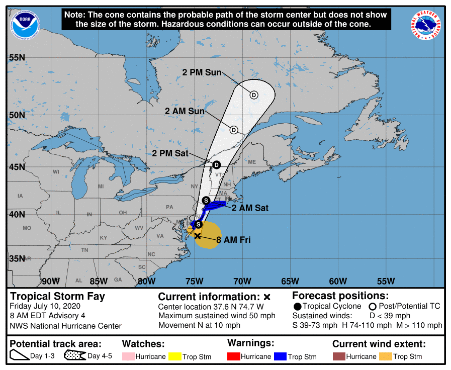
COURT HOUSE – Cape May County remains under a tropical storm warning, according to the National Weather Service (NWS).
The following is the latest forecast from NWS, as of 7:39 a.m. July 10:
Wind
– Latest Local Forecast: Equivalent Tropical Storm force wind
- Peak Wind Forecast: 35-45 mph with gusts to 45 mph
- Window for Tropical Storm force winds: until early this afternoon
– Threat to life and property that includes typical forecast uncertainty in track, size and intensity: Potential for wind 39 to 57 mph
- The wind threat has remained nearly steady from the previous assessment.
- Plan: Plan for hazardous wind of equivalent tropical storm force.
- Prepare: Last minute efforts to protect property should now be complete. The area remains subject to limited wind damage.
- Act: Now is the time to shelter from hazardous wind.
– Potential impacts: Unfolding
- Potential impacts from the main wind event are unfolding.
Storm Surge
– Latest local forecast: Localized storm surge possible
- Peak Storm Surge Inundation: The potential for up to 2 feet above ground somewhere within surge prone areas
- Window of concern: through this afternoon
– Threat to life and property that includes typical forecast uncertainty in track, size and intensity: Potential for storm surge flooding greater than 1 foot above ground
- The storm surge threat has remained nearly steady from the previous assessment.
- Plan: Shelter against storm surge flooding greater than 1 foot above ground.
- Prepare: All flood preparations should be complete. Expect flooding of low-lying roads and property.
- Act: Stay away from storm surge prone areas. Continue to follow the instructions of local officials.
– Potential Impacts: Unfolding
- Potential impacts from the main surge event are unfolding.
Flooding Rain
– Latest Local Forecast: Flash Flood Watch is in effect
- Peak Rainfall Amounts: Additional 1-3 inches, with locally higher amounts
– Threat to life and property that includes typical forecast uncertainty in track, size and intensity: Potential for moderate flooding rain
- The flooding rain threat has remained nearly steady from the previous assessment.
- Plan: Emergency plans should include the potential for moderate flooding from heavy rain. Evacuations and rescues are possible.
- Prepare: Consider protective actions if you are in an area vulnerable to flooding.
- Act: Heed any flood watches and warnings. Failure to take action may result in serious injury or loss of life.
– Potential Impacts: Significant
- Moderate rainfall flooding may prompt several evacuations and rescues.
- Rivers and tributaries may quickly become swollen with swifter currents and overspill their banks in a few places, especially in usually vulnerable spots. Small streams, creeks, canals, arroyos, and ditches overflow.
- Flood waters can enter some structures or weaken foundations. Several places may experience expanded areas of rapid inundation at underpasses, low-lying spots, and poor drainage areas. Some streets and parking lots take on moving water as storm drains and retention ponds overflow. Driving conditions become hazardous. Some road and bridge closures.
Tornado
– Latest Local Forecast:
- Situation is somewhat favorable for tornadoes
– Threat to life and property that includes typical forecast uncertainty in track, size and intensity: Potential for a few tornadoes
- The tornado threat has increased from the previous assessment.
- Plan: Emergency plans should continue to include possible tornadoes.
- Prepare: Stay within your shelter keeping informed of the latest tornado situation.
- Act: Move quickly to the safest place within your shelter if a tornado warning is issued.
– Potential Impacts: Limited
- The occurrence of isolated tornadoes can hinder the execution of emergency plans during tropical events.
- A few places may experience tornado damage, along with power and communications disruptions.
- Locations could realize roofs peeled off buildings, chimneys toppled, mobile homes pushed off foundations or overturned, large tree tops and branches snapped off, shallow-rooted trees knocked over, moving vehicles blown off roads, and small boats pulled from moorings.
Flash Flood Warning
NWS also issued a flash flood warning, which is in effect until 1 p.m. July 10.
According to NWS, flash flooding is being caused by heavy rain.
Protecting yourself from immediate threats to life and safety shall take priority. Whenever possible, as long as it does not cause greater harm, all COVID-19 protective action guidance should be followed.
Turn around… don’t drown when encountering flooded roads. Most flood deaths occur in vehicles.
A flash flood warning means that flooding is imminent or occurring. If you are in the warned area move to higher ground immediately. Residents living along streams and creeks should take immediate precautions to protect life and property.
View NWS’ latest briefing here: https://bit.ly/2APdBqs
NWS will release its next briefing by 1 p.m. July 10.
Be sure to continue to monitor NWS’ latest forecasts for updated information at http:/www.weather.gov/phi/.


