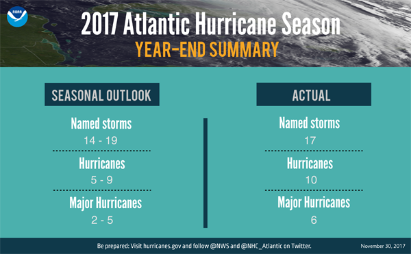
COURT HOUSE – Nov. 30 marked the official end of the 2017 Atlantic hurricane season, which matched NOAA’s seasonal predictions for being extremely active. The season produced 17 named storms of which 10 became hurricanes including six major hurricanes (Category 3, 4 or 5) – including the first two major hurricanes to hit the continental U.S. in 12 years.
“Throughout this devastating hurricane season, NOAA provided vital forecasts and data that helped save many lives,” said U.S. Secretary of Commerce Wilbur Ross. “I commend the scientists and forecasters who worked long hours tracking every storm and guiding federal and local officials’ efforts to prepare and respond.”
Based on the Accumulated Cyclone Energy index, which measures the combined intensity and duration of the storms during the season and is used to classify the strength of the entire hurricane season, 2017 was the seventh most active season in the historical record dating to 1851 and was the most active season since 2005.
Though it was a furious season, NOAA issued early and reliable forecasts to communities in the path of this year’s storms. NOAA’s preliminary data show that the National Hurricane Center issued storm track forecasts with record-setting accuracy. These forecasts for the three most damaging hurricanes were about 25 percent more accurate than average.
This year, three devastating major hurricanes made landfall (Harvey in Texas; Irma in the Caribbean and southeastern U.S.; and Maria in the Caribbean and Puerto Rico). Harvey was also the first major hurricane to hit the U.S. since Wilma struck Florida in October 2005. Additionally, four other storms hit the U.S., including Cindy in Texas, Emily and Phillipe in Florida, and Nate in Mississippi.
“This was a hurricane season that wouldn’t quit,” said retired Navy Rear Adm. Timothy Gallaudet, Ph.D., acting NOAA Administrator. “The season started early with a storm in April and the peak of the season featured an onslaught of ten successive hurricanes. NOAA forecasters rose to this challenge to keep emergency officials and the public aware of anticipated hazards.”
Supporting the accurate forecasts is an array of essential observations that are processed by high-resolution models run by powerful supercomputers – all of which are underpinned by research. Key NOAA activities this season include:
• NOAA aircraft flew more than 500 hours to support forecasting, research and emergency response. Scientists with NOAA Research flew on the aircraft to gather the data used to generate accurate forecasts of the storms’ paths and catastrophic rainfall forecasts. Meanwhile, unmanned aircraft and underwater drones probed Hurricane Maria’s eyewall, soared at 60,000 feet over Hurricane Harvey and dove through the storm-churned waters of the tropical Atlantic and Caribbean to gather unique insights on the storms. Experimental NOAA forecast models run during the storms continue to push the frontiers of weather forecasting skill in storm track, intensity and rainfall amounts. Researchers are now assessing how this data may improve hurricane prediction in the future.
• Forecasters accessed pre-operational imagery from its new geostationary satellite, GOES-16, to track storms with greater detail than ever before. GOES-16 will become operational next month and will be renamed GOES-East. NOAA launched its newest polar-orbiting satellite, JPSS-1, earlier this month and will launch GOES-S next spring. Together, these satellites will provide a significant boost to hurricane monitoring for the 2018 season.
• NOAA’s National Water Center in Tuscaloosa, Alabama, supported local officials in Texas during Hurricane Harvey by providing specialized and supplemental “worst case” river flooding maps for a region that would experience days of excessive rainfall. This tailored decision, coupled with accurate and consistent warnings of historic rainfall and catastrophic flooding from NOAA’s Weather Prediction Center, allowed Texas emergency managers to stage resources, recovery encampments, evacuation areas, and other relief activities safely outside the areas of likely flooding.
• NOAA’s National Ocean Service provided crucial information and expertise before, during and after all of the storms. Leading up to and throughout the storms, NOS issued Storm QuickLooks which provide near real-time coastal and weather data. Once the storms passed, NOS collected more than 65,000 post-storm aerial images in priority areas to assess damage to coastal areas, covering more than 9,200 square miles. NOS also provided emergency hydrographic services at affected port areas. This data was used to detect potential hazards that could delay the delivery of emergency supplies and maritime commerce and help the U.S. Coast Guard to make decisions on reopening ports.
• NOAA’s NWS and National Hurricane Center successfully launched new Storm Surge Watches and Warnings in 2017 for the Atlantic and Gulf coasts of the U.S. Despite a record three landfalling Category 4 hurricanes, there are currently no known deaths from storm surge in the United States. NHC also issued new Potential Tropical Cyclone advisories on seven systems in the Atlantic basin that allowed the timely issuance of watches and warnings for land areas. All but one of these systems went on to develop into a tropical storm or hurricane.
“In six short months, the next hurricane season will be upon us,” added Gallaudet. “This is a good time to review and strengthen your preparedness plans at home as we continue to build a Weather-Ready Nation.”
The 2018 Atlantic hurricane season officially begins on June 1 and NOAA’s Climate Prediction Center will provide its initial seasonal outlook in May.
Cape May – Governor Murphy says he doesn't know anything about the drones and doesn't know what they are doing but he does know that they are not dangerous. Does anyone feel better now?


