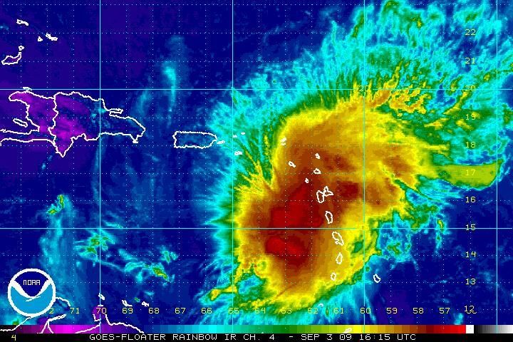
STATE COLLEGE, PA.—- AccuWeather.com reports Erika will batter and will be battered by the northern Caribbean islands this weekend. Dry air and harsh winds high up in the atmosphere could even lead to its total demise. Eventually, the remnants or perhaps a revived Erika may flirt with the southern Atlantic coast next week.
Erika’s main effects are heavy rain and locally gusty thunderstorms. The shoreline and nearby waters will be rough at times. Bathers and boaters will need to be cautious.
While the risks from this include flash flooding and mudslides on the islands, it is also a source of much needed rainfall.
Aside from Puerto Rico, Hispaniola and Cuba, most of the other Caribbean islands and the Bahamas are too small to generate air mass thunderstorms. There simply is not enough heating of the air. So, these areas rely on tropical waves and large scale storms for their source of rainfall.
An interaction with the higher terrain of Puerto Rico into Friday will keep Erika from getting any stronger.
Its path after passing over this island will determine whether or not Erika survives the weekend.
A track over the very mountainous island of Hispaniola could finish Erika off.
What could happen is the center of Erika may shift or reform north or south of these islands. If the shift happens, strengthening could occur.
Regardless of its status or any shifting path, the general area of disturbed weather associated with Erika may reach or get very close to the southern Atlantic coast next week.
It could eventually impact the Southeast with flooding rain and building surf. Interaction with a stalled front in the vicinity will complicate things.
Wildwood Crest – Several of Donald Trump’s Cabinet picks have created quite a bit of controversy over the last few weeks. But surprisingly, his pick to become the next director of the FBI hasn’t experienced as much…


