By Alex Sosnowski, Expert Senior Meteorologist
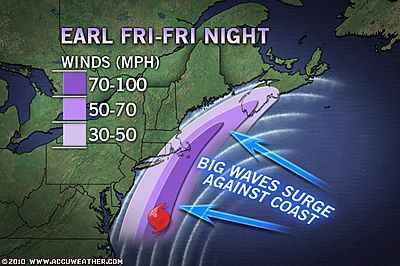
While Hurricane Earl will be passing east of New York City, New Jersey and the Delmarva, coastal areas will feel some dangerous and damaging effects from the massive storm.
First and foremost, building waves into Friday in the region will cause dangerous surf and other coastal problems.
People should stay out of the water, where instructed, due to the powerful waves, and frequent, strong rip currents.
The swells and wind-driven waves will erode some beaches, while over-wash of low-lying coastal roads is a given.
The worst wave and coastal flooding conditions will be in areas that have a northeast exposure to the water and will come during times of high tide following the storm as it moves northward Friday and Friday night after slamming the Outer Banks.
Fortunately, we do “not” have a corresponding new or full moon to add to storm-raised sea levels.
Episodes of strong, gusty winds will also shift northward with the storm, with the worst conditions and the most problems over eastern Long Island and the barrier island communities of New Jersey and Maryland, as well as southeastern Delaware.
These areas run the greatest risk of downed trees and power lines. However, gusty winds before, during and after the storm passes offshore can lead to sporadic problems of the same nature, as well as flight delays and issues with some of the higher bridges in the region.
Rainfall remains somewhat of a question mark at this point, as Earl will change its shape and increase in forward speed.
While AccuWeather.com meteorologists do expect a shield of heavy rain to inundate eastern New England, areas to the west from Hartford, Conn. to Manhattan, to Salisbury, Md. will either get into the rain, or they will not, due to a rather sharp back edge.
There may be a several-hour period of heavy rain affecting Ocean City, Md., Atlantic City, N.J. and Islip, Long Island, along with strong tropical storm conditions.
In the wake of Earl from southwest to northeast late Friday into Saturday as the hurricane exits New England and moves onward to Atlantic Canada, clearing will be nothing short of rapid.
Persistent winds following Earl from the west and northwest will draw progressively cooler, less humid air into the region this weekend.
The offshore winds will lower tide levels, but offshore swells will still cause dangerous rip current conditions in the mid-Atlantic.
Cape May – The number one reason I didn’t vote for Donald Trump was January 6th and I found it incredibly sad that so many Americans turned their back on what happened that day when voting. I respect that the…


