CAPE MAY – With the official hurricane forecast indicating “another above-normal hurricane season this year,” the National Weather Service (NWS) stresses that it “only takes one storm to have an impact on an area with a sea surge, wind damage or flooding,” so residents should be prepared.
The National Oceanic and Atmosphere Administration (NOAA) Climate Prediction Center released its hurricane forecast May 25 for the June 1-Nov. 30 season.
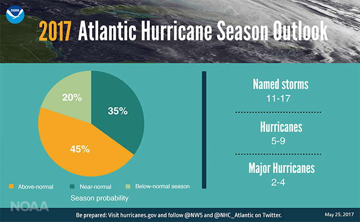
Forecasters predict a 45 percent chance of an above-normal season, a 35 percent chance of a near-normal season, and only a 20 percent chance of a below-normal season.
NOAA warns of dangerous weather, charts seas, guides the use and protection of ocean and coastal resources and conducts research to improve understanding and stewardship of the environment.
At a news conference to announce the forecast, experts stressed the importance of planning for a hurricane rather than waiting until it is near.
An exhibit entitled Cape May’s “Stormy Past,” including the nor’easters of 1933, 1962 and 2010 and others, and the 1944 hurricane is on display at the Carroll Gallery in the Carriage House of the Emlen Physick Estate, 1048 Washington Street, Cape May. The exhibit depicts the damage a storm can render.
“A tropical storm can be just as dangerous,” said Ben Friedman, acting NOAA administrator. “Just because a storm is not a major one does not mean there won’t be damage. Flooding and storm surge can be just as dangerous. While we can predict the likelihood of a storm, we can’t predict when, where or how a storm will occur so if you live in a hurricane-prone area, prepare now.”
Forecasters predict a 70 percent likelihood of 11 to 17 named storms (winds of 39 mph or higher), of which five to nine could become hurricanes (winds of 74 mph or higher), including two to four major hurricanes (Category 3, 4 or 5; winds of 111 mph or higher).
An average season produces 12 named storms of which six become hurricanes, including three major hurricanes.
These numbers include Tropical Storm Arlene, a rare pre-season storm that formed over the eastern Atlantic in April.
Procedures established by the World Meteorological Organization have established a list of names to be used in rotation and recycled every six years for Atlantic hurricanes.
Arlene will be followed by Bret, Cindy, Don and others. The only time there is a change is if a storm was so deadly or costly that use of its name on a different storm would be inappropriate.
“The outlook reflects our expectation of a weak or non-existent El Nino, near- or above-average sea-surface temperatures across the tropical Atlantic Ocean and the Caribbean Sea, and average or weaker-than-average vertical wind shear in that same region,” said Dr. Gerry Bell, the lead seasonal hurricane forecaster with NOAA’s Climate Prediction Center.
Strong El Ninos and wind shear typically suppress the development of Atlantic hurricanes, so the prediction for weak conditions points to more hurricane activity this year.
Also, warmer sea surface temperatures tend to fuel hurricanes as they move across the ocean. However, the climate models are showing considerable uncertainty, which is reflected in the comparable probabilities for an above-normal and near-normal season.
“The key is whether it’s going to be an active or quiet season,” said Meteorologist Lance Franck, of the Mount Holly National Weather Service office.
“For the Cape May County area, it’s really the storm surge and damaging winds that residents need to be concerned with versus inland where typically only flooding will occur. The storm surge and damaging winds can cause flooding, power outages and all sorts of damage that residents need to be prepared for; the saying is run from water, hide from the wind.”
May 7-13 was declared Hurricane Preparedness Week by NOAA, whose members traveled throughout the eastern U.S. to spread the word on being prepared. Videos and other material can be found at the website https://www.weather.gov/wrn/hurricane-preparedness.
Franck said usually the more impactful storms occur in July, August and September when the water is warmer.
“If there is a named storm in the Bahamas, then county residents should pay attention,” he noted. “Later in the season the potential for storms increases because the water temperatures allow the storms to maintain their intensity.”
However, he was quick to underscore that storms can hit the Cape May County area at any time, with nor’easters occurring during the winter.
He noted the January 2016 blizzard, which caused major coastal flooding in the area.
“Winter storms can cause the same impact as a hurricane, especially along the coastal areas with their strong winds and storm surges,” Franck said. “It only takes one storm to be devastating so you should have a plan for water surges, high winds, power outages, and flooding.”
The Ash Wednesday Nor’easter storm of March 1962 was an example of how damaging a winter storm can be; the meteorologist pointed out.
It killed 40 people and injured more than 1,000 when it hit the mid-Atlantic coast of the U.S. March 6-8, 1962. Coastal areas from North Carolina to New York were battered and changed forever by the wind, waves and record high tides.
Thousands of homes and businesses were flooded and many destroyed. Property damage in six states was valued in the hundreds of millions of dollars.
Its impact was so powerful that the U. S. Weather Bureau took the extraordinary step of giving it a name: “The Great Atlantic Storm.”
It is also known as “Five High Storm” because it lingered off the Atlantic Coast of the northeastern United States over a period of five high tides. However, because the heaviest damages occurred in most areas on Wednesday, March 7, the first day of Lent that year, it has become most popularly well known as the “Ash Wednesday Storm of 1962.”
Images taken after the March storm of 1962, which devastated the Cape May beachfront and boardwalk and caused catastrophic flooding throughout Cape May County and others are featured in the exhibit, “Cape May’s Stormy Past: From the Pages of The First Resort.”
Exhibit Curator Ben Miller, who authored “The First Resort,” provides visitors with an “unforgettable look at iconic storms that have ravaged Cape May, allowing viewers to see and appreciate the awesome power of Mother Nature.” Text and images are complemented by the works of select Cape May artists; artwork will be auctioned 7 p.m. Oct. 6.
The exhibit is presented by the Mid-Atlantic Center for the Arts & Humanities (MAC). The exhibit is open daily through Oct. 9; times vary. Admission is free.
To contact Karen Knight, email kknight@cmcherald.com.
Cape May – Governor Murphy says he doesn't know anything about the drones and doesn't know what they are doing but he does know that they are not dangerous. Does anyone feel better now?


